Report on Krafla (Iceland) — May 1987

Scientific Event Alert Network Bulletin, vol. 12, no. 5 (May 1987)
Managing Editor: Lindsay McClelland.
Krafla (Iceland) Gradual inflation during late 1986, early 1987
Please cite this report as:
Global Volcanism Program, 1987. Report on Krafla (Iceland) (McClelland, L., ed.). Scientific Event Alert Network Bulletin, 12:5. Smithsonian Institution. https://doi.org/10.5479/si.GVP.SEAN198705-373080
Krafla
Iceland
65.715°N, 16.728°W; summit elev. 800 m
All times are local (unless otherwise noted)
"Gradual inflation began in November 1986 after almost two years of insignificant ground deformation. Extensive tilt measurements in late October 1986 and late April 1987, and several measurements in late February and early March 1987 show that the inflation affected the same area as it did in 1976-82. The observed tilt agrees reasonably with a single point source model. Tilt measurements in late February and early March 1987 indicated a maximum uplift of 17.8 cm since late October 1986 with a point source at 2.5 km depth. The observations in late April 1987 (figure 10) indicated a maximum uplift of 22.0 cm and a point source depth of 2.7 km.
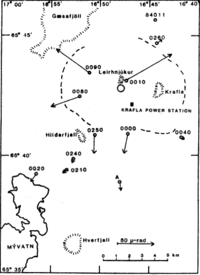 |
Figure 10. Observed tilt at eleven optical level tilt stations near Krafla during the November 1986-March 1987 inflation. The open circle S of Leirhnjúkur shows the location of a single point source that can explain most of the observed ground deformation if source depth is 2.5-2.7 km. The dashed line marks the caldera boundary. |
"Extensive distance measurements in the Krafla region in late February and early March 1987 were compared with measurements of March 1986. Lines inside the Krafla caldera had increased up to 70 ppm in length. Comparison with a point source model showed best agreement if the point source was at 2.7 km depth and the central uplift was 19.5 cm.
"Thus, both tilt measurements and distance measurements agree on the depth of a point source and the maximum uplift. Geographic coordinates of the indicated point source are about 65°42.8'N, 16°47.6'W if distance measurements are considered but about 0.6 km farther W if tilt measurements are considered. This discrepancy is apparently caused by systematic anomalies in the azimuth of tilt at several stations, making the coordinates obtained from distance measurements more reliable. The recording tiltmeters at the Krafla power station (figure 11) indicated a constant rate of inflation from early November 1986 until the end of March 1987, when inflation ceased. Seismic activity in the Krafla region increased slightly during this inflation period and reached its highest value in late February and March, 1987."
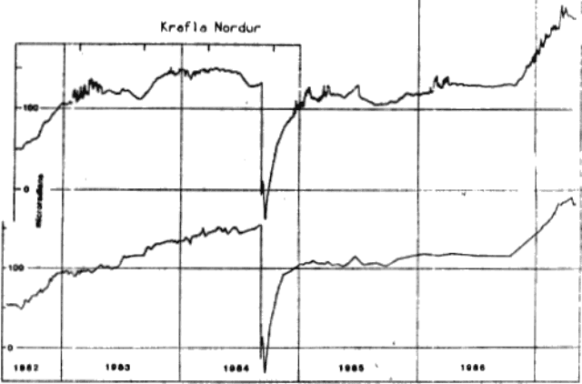 |
Figure 11. North component of tilt at the Krafla power station from mid-1983 to early May 1987. Up on the graph is uplift towards the N. The electronic tiltmeter (upper curve) shows high noise level during winter and minima in July or August, both caused by surface strain of thermal origin. The record of the water tube tiltmeter (lower curve) is less disturbed by thermal strain. |
Further References. Tryggvason, E., 1986, Vertical ground movement in the Krafla region 1977-1986: Nordic Volcanological Institute, Univ of Iceland, no. 8602, 31 p.
Tryggvason, E., 1987, Myvatn lake level observations 1984-1986 and ground deformation during a Krafla eruption: JVGR, v. 31, p. 131-138.
Geological Summary. The Krafla volcanic system in the Northern Volcanic Zone (NVZ) of Iceland is about 100 km long, consisting of a fissure swarm and a central volcano with a 7 x 9 km caldera formed about 110,000 years ago that deposited a rhyolitic welded tuff. It has been moderately active in the Holocene, over three distinct eruptive periods; the current one has lasted about 2,800 years with six volcano-tectonic episodes, each with one or more basaltic fissure eruptions. Lava volumes (DRE) have been in the 0.1-1 km3 range. The Hverfjall and Ludent tuff rings east of Myvatn were erupted along the fissure system. Myvatn lake formed during the eruption of the older Laxarhraun lava flow from the Ketildyngja shield volcano of the Fremrinamur volcanic system about 3,800 years before present (BP); The present Myvatn lake is constrained by the roughly 2,000 years BP younger Laxarhraun lava flow from the Krafla volcanic system. The abundant pseudocraters that form a prominent part of the Myvatn landscape were created when the younger Laxarhraun lava flow entered the lake. The last eruption took place in 1975-1984 CE when nine small basaltic fissure eruptions produced 0.25 km3 of lava.
Information Contacts: E. Tryggvason, NVI.