Report on Erta Ale (Ethiopia) — June 1987
Scientific Event Alert Network Bulletin, vol. 12, no. 8 (June 1987)
Managing Editor: Lindsay McClelland.
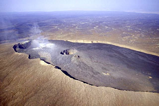
Erta Ale (Ethiopia) Landsat data show two crusted lava lakes
Please cite this report as:
Global Volcanism Program, 1987. Report on Erta Ale (Ethiopia) (McClelland, L., ed.). Scientific Event Alert Network Bulletin, 12:8. Smithsonian Institution. https://doi.org/10.5479/si.GVP.SEAN198706-221080
Erta Ale
Ethiopia
13.601°N, 40.666°E; summit elev. 585 m
All times are local (unless otherwise noted)
The following is abstracted from Rothery and others (1988). Landsat TM data acquired 5 January 1986 show both lakes. The northern one had shrunk to no more than 60 m across and the S lake was ~150 m in diameter. Temperatures derived from the data suggest that the lakes were quiescent with cool (< 400°C) crust. Incandescent cracks at ~1,150°C occupied < 0.4% of the surface area.
Reference. Rothery, D.A., Francis, P.W., and Wood, C.A., 1988, Volcano monitoring using short wavelength infrared data from satellites: JGR, v. 93, no. B7, p. 7993-8008.
Geological Summary. The Erta Ale basaltic shield volcano in Ethiopia has a 50-km-wide edifice that rises more than 600 m from below sea level in the Danakil depression. The volcano includes a 0.7 x 1.6 km summit crater hosting steep-sided pit craters. Another larger 1.8 x 3.1 km wide depression elongated parallel to the trend of the Erta Ale range is located SE of the summit and is bounded by curvilinear fault scarps on the SE side. Basaltic lava flows from these fissures have poured into the caldera and locally overflowed its rim. The summit caldera usually also holds at least one long-term lava lake that has been active since at least 1967, and possibly since 1906. Recent fissure eruptions have occurred on the N flank.
Information Contacts: D. Rothery, Open Univ.