Report on Mahawu (Indonesia) — June 1987
Scientific Event Alert Network Bulletin, vol. 12, no. 6 (June 1987)
Managing Editor: Lindsay McClelland.
Mahawu (Indonesia) Lake volume and temperature increase, seismicity rises
Please cite this report as:
Global Volcanism Program, 1987. Report on Mahawu (Indonesia) (McClelland, L., ed.). Scientific Event Alert Network Bulletin, 12:6. Smithsonian Institution. https://doi.org/10.5479/si.GVP.SEAN198706-266110
Mahawu
Indonesia
1.352°N, 124.865°E; summit elev. 1299 m
All times are local (unless otherwise noted)
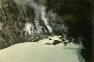
A 100-m white plume was first seen emerging from the summit crater on 17 April (12:04). A similar whitish plume was continuously present above the summit in May and June. Both tectonic and volcanic earthquakes had increased at the end of April and continued to be recorded in May and June. By 30 June, the crater lake volume had increased to 45,000 m3 and water temperature had increased to 48°C.
Geological Summary. The elongated Mahawu volcano immediately east of Lokon-Empung volcano is the northernmost of a series of young volcanoes along a SSW-NNE line near the margin of the Quaternary Tondano caldera. Mahawu is capped by a 180-m-wide, 140-m-deep crater that sometimes contains a small crater lake, and has two pyroclastic cones on its N flank. Historical activity has been restricted to occasional small explosive eruptions recorded since 1789. In 1994 fumaroles, mudpots, and small geysers were observed along the shores of a greenish-colored crater lake.
Information Contacts: VSI.