Report on Kilauea (United States) — June 1987

Scientific Event Alert Network Bulletin, vol. 12, no. 6 (June 1987)
Managing Editor: Lindsay McClelland.
Kilauea (United States) Lava flow builds coast, destroys house; inflation resumes
Please cite this report as:
Global Volcanism Program, 1987. Report on Kilauea (United States) (McClelland, L., ed.). Scientific Event Alert Network Bulletin, 12:6. Smithsonian Institution. https://doi.org/10.5479/si.GVP.SEAN198706-332010
Kilauea
United States
19.421°N, 155.287°W; summit elev. 1222 m
All times are local (unless otherwise noted)
Lava continued to emerge along the S coast from the tube system . . . . On 4 June lava again entered the ocean, and continued to flow into the sea until late in the month. It was more active 10-24 June than at any time since it entered the ocean, flowing at an increased rate, generating steam clouds and black sand, and forming pillow lavas. The flow front was ~700 m wide as it entered the ocean and extended at least 50 m from the old shore. The flow into the ocean declined 25-26 June and stopped between the 27th and the 30th.
Although no aerial photos have been taken, and no estimate made of the amount of new land added to the island, figure 50 shows the ~1.5 km of new shoreline.
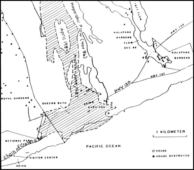 |
Figure 50. Sketch map of the S coast of Hawaii showing Kīlauea's March-June lava flows and the approximate position of the new shoreline. |
From 1 to 6 June, lava threatened the two remaining houses in the kipuka formed in November, and on the 6th, one was destroyed. From 8 June, lava threatened to bury the remains of an historic church established by Father Damien, a famous Hawaiian cleric, and a beach house off the edge of the November 1986 flow margin. By the end of the month, the old church was surrounded by 3-4 m of lava. On the 29th, a lobe of the lava flow covered another 200 m of highway reconstructed after the November-December blockage. It flowed across the highway and moved E, funneling into a small graben behind the beach house. Inland, at the shield surrounding the vent, activity remained about the same. The level of the lava pond fluctuated between overflowing and 5 m below the rim. Tumescence on the N flank of the shield has continued but at a reduced rate.
On 25 June at 2146 a moderate seismic event occurred, associated with partial collapse of the conduit at Pu`u `O`o, the sole source of lava production from 13 June 1983 to 19 July 1986. When part of the conduit wall collapsed, the conduit was enlarged from 10 to 30-40 m in diameter. Bright red magma was sighted ~100 m down in the inactive vent, before it crusted over. There was a high rate of microshocks caused by rockfalls from the conduit walls and resulting structural readjustments within the cone.
Harmonic tremor continued at low level . . . near the eruption site. The number of shallow short-period earthquakes remained nearly constant at average levels. There was a swarm of intermediate-depth long-period events during the second week of June (figure 51).
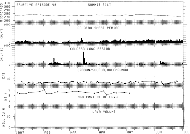 |
Figure 51. Kīlauea's activity, January-June 1987, showing summit tilt, short- and long-period earthquakes, carbon/sulfur ratio of summit gases, MgO content of lavas, and estimated lava volume. |
The E-W tiltmeter at Kīlauea's summit indicated an inflationary trend following almost a month of gradual deflation. The level of tilt remained low relative to the peak of inflation prior to E-48 (19 July 1986).
Geological Summary. Kilauea overlaps the E flank of the massive Mauna Loa shield volcano in the island of Hawaii. Eruptions are prominent in Polynesian legends; written documentation since 1820 records frequent summit and flank lava flow eruptions interspersed with periods of long-term lava lake activity at Halemaumau crater in the summit caldera until 1924. The 3 x 5 km caldera was formed in several stages about 1,500 years ago and during the 18th century; eruptions have also originated from the lengthy East and Southwest rift zones, which extend to the ocean in both directions. About 90% of the surface of the basaltic shield volcano is formed of lava flows less than about 1,100 years old; 70% of the surface is younger than 600 years. The long-term eruption from the East rift zone between 1983 and 2018 produced lava flows covering more than 100 km2, destroyed hundreds of houses, and added new coastline.
Information Contacts: C. Heliker and R. Koyanagi, HVO.