Report on Cleveland (United States) — August 1987
Scientific Event Alert Network Bulletin, vol. 12, no. 8 (August 1987)
Managing Editor: Lindsay McClelland.
Cleveland (United States) Possible source of 10.6-km cloud; lava flow
Please cite this report as:
Global Volcanism Program, 1987. Report on Cleveland (United States) (McClelland, L., ed.). Scientific Event Alert Network Bulletin, 12:8. Smithsonian Institution. https://doi.org/10.5479/si.GVP.SEAN198708-311240
Cleveland
United States
52.825°N, 169.944°W; summit elev. 1730 m
All times are local (unless otherwise noted)
During at least five overflights between 6 and 10 August, H. Wilson (Peninsula Airways) observed incandescent lava and summit glow, but did not recognize any lava fountains or moving flows. High-pressure steam emission was occurring and steam drifted as far as 3 km from the summit. At about 1500 on 26 August, pilot T. Madsen (Aleutian Air) observed a 600-m-high ash and steam plume. Two days later, on 28 August at about 0930, Scott Kerr and Pete Galaktionoff heard a distant rumbling sound lasting ~15 seconds while camping on Kagamil Island (25 km NE of Mt. Cleveland, 120 km NE of Amukta). Overcast skies prevented observations. At 0944 that day the National Warning Center of the North American Air Defense Command (NORAD) issued a warning of a large eruption of Mt. Cleveland, after detecting a hot spot that morning at 52.78°N, 169.93°W through remote sensing. Steve Shivers (USGS Anchorage) recognized a WNW-trending plume on a NOAA 10 satellite image returned at 1030. The ~15-km plume was elongated WNW from a point ~15 km W of Mt. Cleveland. From more than 100 km away at about 1100, pilot Charles Nickerson (Reeve Aleutian Airways) reported that the plume, which appeared to be drifting WNW, reached 9-10.6 km altitude with about a 25 km upper radius, but the plume was by then apparently detached from its origin and the volcano that fed it is not certain. He estimated that the plume was just ENE of Amukta and W of Cleveland. Mt. Cleveland's summit appeared to be emitting a 300 m-high steam plume. At about 1200, Larry Conner (MarkAir) also observed the eruption plume from a point ~30 km S of Amukta, which was completely covered by clouds and not emitting a plume. At about 1400, pilot William Redmond (Peninsula Airways) observed unusual, thin, brown-tinted, cirrus layers beginning 65 km WNW of Mt. Cleveland at 2,400 m altitude and higher. The wind was blowing from the E.
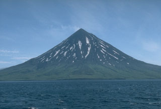
Geological Summary. The beautifully symmetrical Mount Cleveland stratovolcano is situated at the western end of the uninhabited Chuginadak Island. It lies SE across Carlisle Pass strait from Carlisle volcano and NE across Chuginadak Pass strait from Herbert volcano. Joined to the rest of Chuginadak Island by a low isthmus, Cleveland is the highest of the Islands of the Four Mountains group and is one of the most active of the Aleutian Islands. The native name, Chuginadak, refers to the Aleut goddess of fire, who was thought to reside on the volcano. Numerous large lava flows descend the steep-sided flanks. It is possible that some 18th-to-19th century eruptions attributed to Carlisle should be ascribed to Cleveland (Miller et al., 1998). In 1944 it produced the only known fatality from an Aleutian eruption. Recent eruptions have been characterized by short-lived explosive ash emissions, at times accompanied by lava fountaining and lava flows down the flanks.
Information Contacts: J. Reeder, ADGGS.