Report on Whakaari/White Island (New Zealand) — October 1987

Scientific Event Alert Network Bulletin, vol. 12, no. 10 (October 1987)
Managing Editor: Lindsay McClelland.
Whakaari/White Island (New Zealand) Explosions and ash emission; moderate seismicity
Please cite this report as:
Global Volcanism Program, 1987. Report on Whakaari/White Island (New Zealand) (McClelland, L., ed.). Scientific Event Alert Network Bulletin, 12:10. Smithsonian Institution. https://doi.org/10.5479/si.GVP.SEAN198710-241040
Whakaari/White Island
New Zealand
37.52°S, 177.18°E; summit elev. 294 m
All times are local (unless otherwise noted)
Intermittent ash eruption, with occasional larger explosive events, has continued since the last inspection on 7 September. An overflight on [15] October showed that the main crater floor was covered with dark ash. Congress Crater appeared to have deepened and the active vent emerged some distance above the crater floor.
Seismicity has remained at moderate levels since 7 September, dominated by medium- to high-frequency volcanic tremor. NZGS personnel thought it likely that episodes recorded 17-22 and 25-28 September accompanied significant ash emission. Several eruption-type earthquake sequences have been recorded since 7 September. These eruptive episodes, probably of similar size to the observed 7 September episode, have deposited block ejecta and left impact craters on the W part of the main crater floor. Volcanic earthquake events (E-type) that occurred between 7 September and 16 October were strongest on 12 and 13 September. Each event began with a sequence of C-type events followed 50-70 seconds later by a symmetric envelope of higher frequency (4-10 Hz) signal, interpreted as the time of the explosive eruption of ash and blocks from the vent (figure 9).
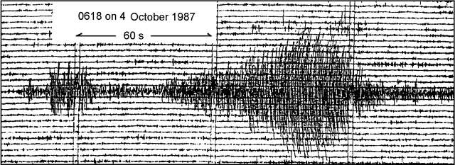 |
Figure 9. Typical example of an E-type volcanic earthquake at White Island, beginning with a sequence of C-type events. Courtesy of NZGS. |
Geological Summary. The uninhabited Whakaari/White Island is the 2 x 2.4 km emergent summit of a 16 x 18 km submarine volcano in the Bay of Plenty about 50 km offshore of North Island. The island consists of two overlapping andesitic-to-dacitic stratovolcanoes. The SE side of the crater is open at sea level, with the recent activity centered about 1 km from the shore close to the rear crater wall. Volckner Rocks, sea stacks that are remnants of a lava dome, lie 5 km NW. Descriptions of volcanism since 1826 have included intermittent moderate phreatic, phreatomagmatic, and Strombolian eruptions; activity there also forms a prominent part of Maori legends. The formation of many new vents during the 19th and 20th centuries caused rapid changes in crater floor topography. Collapse of the crater wall in 1914 produced a debris avalanche that buried buildings and workers at a sulfur-mining project. Explosive activity in December 2019 took place while tourists were present, resulting in many fatalities. The official government name Whakaari/White Island is a combination of the full Maori name of Te Puia o Whakaari ("The Dramatic Volcano") and White Island (referencing the constant steam plume) given by Captain James Cook in 1769.
Information Contacts: A. Cody, I. Nairn, and B. Scott, NZGS Rotorua.