Report on Ebeko (Russia) — October 1987
Scientific Event Alert Network Bulletin, vol. 12, no. 10 (October 1987)
Managing Editor: Lindsay McClelland.
Ebeko (Russia) Ash ejections to 1 km; steaming fissures form
Please cite this report as:
Global Volcanism Program, 1987. Report on Ebeko (Russia) (McClelland, L., ed.). Scientific Event Alert Network Bulletin, 12:10. Smithsonian Institution. https://doi.org/10.5479/si.GVP.SEAN198710-290380
Ebeko
Russia
50.686°N, 156.014°E; summit elev. 1103 m
All times are local (unless otherwise noted)
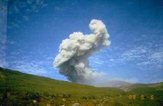
Beginning 14 October, two vents on a sheer wall of the N crater began ejecting fine ash and steam to 300 m above the summit. Pulsations of activity occurred 3 or 4 times a day. Ejections reached 1 km height, with a plume that extended horizontally 10-15 km NE. Fissures that formed on the outer E flank of the crater emitted steam. No seismicity preceded or accompanied the ash-steam ejections. The press reported that ash and gas began to be emitted from the main crater before 2100 on 19 October, and the crater lake was emptied of water. A 1-km-high ash column formed on 27 October and the next day a small amount of ash fell on the town of Severo-Kurilsk (a few kilometers away). No casualties resulted from the eruptions. Additional equipment was installed to monitor the volcano. Variations in gas composition of near-crater fumaroles were observed 4 years ago, and an increase in the temperatures of fumarole emissions has been noted since the October eruption. The press reported that scientists did not rule out the possiblilty of a lahar which could pose a danger to the S part of Severo-Kurilsk.
Geological Summary. The flat-topped summit of the central cone of Ebeko volcano, one of the most active in the Kuril Islands, occupies the northern end of Paramushir Island. Three summit craters located along a SSW-NNE line form Ebeko volcano proper, at the northern end of a complex of five volcanic cones. Blocky lava flows extend west from Ebeko and SE from the neighboring Nezametnyi cone. The eastern part of the southern crater contains strong solfataras and a large boiling spring. The central crater is filled by a lake about 20 m deep whose shores are lined with steaming solfataras; the northern crater lies across a narrow, low barrier from the central crater and contains a small, cold crescentic lake. Historical activity, recorded since the late-18th century, has been restricted to small-to-moderate explosive eruptions from the summit craters. Intense fumarolic activity occurs in the summit craters, on the outer flanks of the cone, and in lateral explosion craters.
Information Contacts: S. Fedotov and I. Menyailov, IV; G. Steinberg, Yuzhno-Sakhalinsk; Moscow Domestic Service; Soviet Sakhalin newspaper.