Report on Pacaya (Guatemala) — December 1987

Scientific Event Alert Network Bulletin, vol. 12, no. 12 (December 1987)
Managing Editor: Lindsay McClelland.
Pacaya (Guatemala) Cone destruction and subsequent growth; lava flows
Please cite this report as:
Global Volcanism Program, 1987. Report on Pacaya (Guatemala) (McClelland, L., ed.). Scientific Event Alert Network Bulletin, 12:12. Smithsonian Institution. https://doi.org/10.5479/si.GVP.SEAN198712-342110
Pacaya
Guatemala
14.382°N, 90.601°W; summit elev. 2569 m
All times are local (unless otherwise noted)
Alfredo MacKenney provided the following observations of activity between 14 June and 22 November 1987.
14 June: From 0800-0900 an intense eruption sent an ash column to approximately 8 km. Lava flows descended N. MacKenney Cone was partially destroyed (figure 2). 5 July: A small cone was forming on the crater floor as its four craters ejected scoria and ash. 2 August: The new cone surpassed the borders of MacKenney Crater and was visible from the summit of Pacaya. Lava began flowing SW from the base of the new cone. 30 August: The growth of the new cone was noticeable. It had four active vents. 13 September: The new cone had continued growing. 25 October: The new cone occupied almost all of MacKenney Crater. Explosive activity persisted in the cone's 3 upper craters. From the E base the cone had reached 50 m height. 22 November: The new cone had surpassed the height of the previous cones that had, in 1775, reached the altitude of Pacaya's summit crater. Lava continued to flow SW from the base of the new MacKenney cone (figure 2).
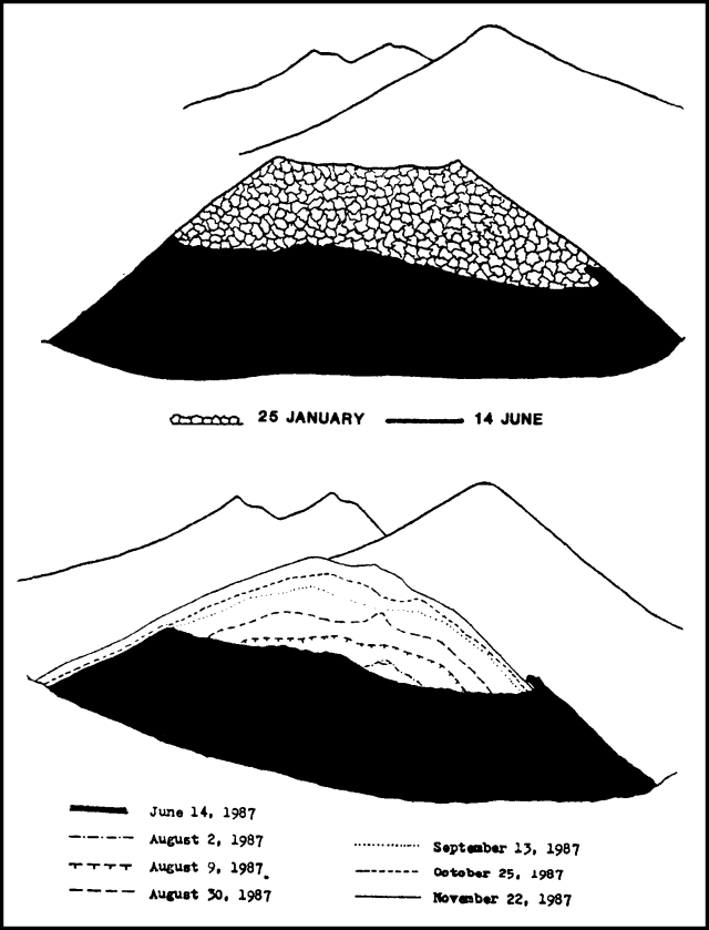 |
Figure 2. View from Pacaya's summit showing the effect of 14 June 1987 explosive activity on MacKenney Cone (top) and the re-formation of MacKenney Cone through 22 November 1987. Courtesy of Alfredo MacKenney. |
Geological Summary. Eruptions from Pacaya are frequently visible from Guatemala City, the nation's capital. This complex basaltic volcano was constructed just outside the southern topographic rim of the 14 x 16 km Pleistocene Amatitlán caldera. A cluster of dacitic lava domes occupies the southern caldera floor. The post-caldera Pacaya massif includes the older Pacaya Viejo and Cerro Grande stratovolcanoes and the currently active Mackenney stratovolcano. Collapse of Pacaya Viejo between 600 and 1,500 years ago produced a debris-avalanche deposit that extends 25 km onto the Pacific coastal plain and left an arcuate scarp inside which the modern Pacaya volcano (Mackenney cone) grew. The NW-flank Cerro Chino crater was last active in the 19th century. During the past several decades, activity has consisted of frequent Strombolian eruptions with intermittent lava flow extrusion that has partially filled in the caldera moat and covered the flanks of Mackenney cone, punctuated by occasional larger explosive eruptions that partially destroy the summit.
Information Contacts: A. MacKenney, Guatemala City.