Report on Cerro Negro (Nicaragua) — January 1988
Scientific Event Alert Network Bulletin, vol. 13, no. 1 (January 1988)
Managing Editor: Lindsay McClelland.
Cerro Negro (Nicaragua) Fieldwork reveals few changes since 1985-86; fumarole temperatures
Please cite this report as:
Global Volcanism Program, 1988. Report on Cerro Negro (Nicaragua) (McClelland, L., ed.). Scientific Event Alert Network Bulletin, 13:1. Smithsonian Institution. https://doi.org/10.5479/si.GVP.SEAN198801-344070
Cerro Negro
Nicaragua
12.506°N, 86.702°W; summit elev. 728 m
All times are local (unless otherwise noted)
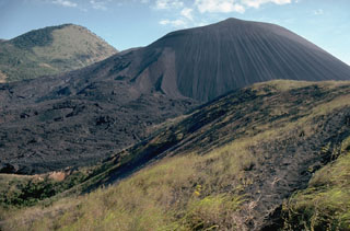
When visited on 16 January, little change was noted from 1985-86. Some fumaroles have stopped emitting gases, but other new ones have formed. Vegetation has begun to appear on the crater's eastern rock buttress. When measured by infrared radiometer from 1-5 m distance, the temperatures of 10 fumaroles generally ranged from 100-200°C, with a maximum of 228°. Averaging over larger areas yielded temperatures of 100°C+ (100 m2) and 60°C+ (1,000 m2). Other temperature data are shown beside figure 2. Cerro Negro has been the site of frequent activity since 1850, most recently in 1971 when explosive activity from the summit and E flank fed 6-km clouds.
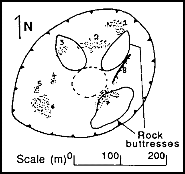 |
Figure 2. Sketch map of Cerro Negro's crater on 16 January 1988. Temperature measurements (of points labeled on the map) from about 200 m distance: (2-7) 40-50°C (10 m2 resolution, total ± 2,000 m2); (8) 50°C+ (25 m2). Temperatures were taken with an infrared radiometer measuring surface brightness temperature in the 8-14 µm range with emissivity set at 1. |
Geological Summary. Nicaragua's youngest volcano, Cerro Negro, was created following an eruption that began in April 1850 about 2 km NW of the summit of Las Pilas volcano. It is the largest, southernmost, and most recent of a group of four youthful cinder cones constructed along a NNW-SSE-trending line in the central Marrabios Range. Strombolian-to-subplinian eruptions at intervals of a few years to several decades have constructed a roughly 250-m-high basaltic cone and an associated lava field constrained by topography to extend primarily NE and SW. Cone and crater morphology have varied significantly during its short eruptive history. Although it lies in a relatively unpopulated area, occasional heavy ashfalls have damaged crops and buildings.
Information Contacts: B. van Wyk de Vries, H. Rymer, and G. Brown, Open Univ; P. Hradecky and H. Taleno, INETER.