Report on Erebus (Antarctica) — February 1988

Scientific Event Alert Network Bulletin, vol. 13, no. 2 (February 1988)
Managing Editor: Lindsay McClelland.
Erebus (Antarctica) Lava lakes; Strombolian activity; collapse; SO2 data
Please cite this report as:
Global Volcanism Program, 1988. Report on Erebus (Antarctica) (McClelland, L., ed.). Scientific Event Alert Network Bulletin, 13:2. Smithsonian Institution. https://doi.org/10.5479/si.GVP.SEAN198802-390020
Erebus
Antarctica
77.53°S, 167.17°E; summit elev. 3794 m
All times are local (unless otherwise noted)
"Mt. Erebus was visited by New Zealand and U.S. scientists during November and December 1987. Activity generally remained unchanged from the previous year. The small active anorthoclase phonolite lava lake has increased in size, from about 20 m in diameter a year ago to about 30 m (figure 9). It fluctuated in height by as much as 2-5 m over periods of <1 hour. Such marked fluctuations have not been previously recorded during periods of quiet degassing. Two other small lava lakes, both <10 m in diameter, were observed. One was transient, and only appeared when the lava level was high in the main lake.
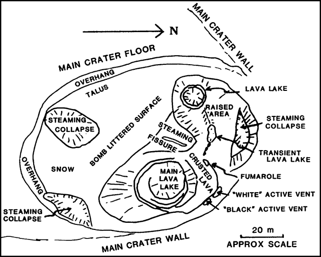 |
Figure 9. Sketch map of the inner crater of Mt. Erebus on 1 December 1987. Courtesy of Philip Kyle. |
"For about a month, from mid-November to mid-December, explosive activity was mild and consisted of small Strombolian eruptions, primarily from the main lava lake. Small eruptions also occurred from two possibly inclined vents at the base of the crater wall, NE of the main lava lake. During this period, no bombs were ejected from the inner crater. In late December, the Strombolian eruptions increased in size, with bombs landing on the main crater floor and rim.
"In early December, a crescent-shaped segment of the main crater floor and inner crater wall, ~60 m long and 10 m wide, collapsed into the southern part of the inner crater. It filled the large steaming collapse site SW of the main lava lake, and covered the S half of the inner crater with talus and debris. Large steaming fissures on the main crater floor suggest that further collapse is imminent.
"COSPEC measurements indicated that the average SO2 emission rate has increased to ~50 t/d. The average flux seemed to be a function of the lava lake surface area. As the lakes have increased in size, so has the SO2 flux. Significant and regular variations in the SO2 emission rates were observed, and may be correlated with changes in the rate of convection within the lava lake."
Geological Summary. Mount Erebus, the world's southernmost historically active volcano, overlooks the McMurdo research station on Ross Island. It is the largest of three major volcanoes forming the crudely triangular Ross Island. The summit of the dominantly phonolitic volcano has been modified by one or two generations of caldera formation. A summit plateau at about 3,200 m elevation marks the rim of the youngest caldera, which formed during the late-Pleistocene and within which the modern cone was constructed. An elliptical 500 x 600 m wide, 110-m-deep crater truncates the summit and contains an active lava lake within a 250-m-wide, 100-m-deep inner crater; other lava lakes are sometimes present. The glacier-covered volcano was erupting when first sighted by Captain James Ross in 1841. Continuous lava-lake activity with minor explosions, punctuated by occasional larger Strombolian explosions that eject bombs onto the crater rim, has been documented since 1972, but has probably been occurring for much of the volcano's recent history.
Information Contacts: P. Kyle, Univ. of London.