Report on Piton de la Fournaise (France) — May 1988

Scientific Event Alert Network Bulletin, vol. 13, no. 5 (May 1988)
Managing Editor: Lindsay McClelland.
Piton de la Fournaise (France) Intrusion, then lava from fissure vents
Please cite this report as:
Global Volcanism Program, 1988. Report on Piton de la Fournaise (France) (McClelland, L., ed.). Scientific Event Alert Network Bulletin, 13:5. Smithsonian Institution. https://doi.org/10.5479/si.GVP.SEAN198805-233020
Piton de la Fournaise
France
21.244°S, 55.708°E; summit elev. 2632 m
All times are local (unless otherwise noted)
The fissure eruption . . . stopped on 2 April. A well-documented intrusion preceded a large N-flank fissure eruption that began on 18 May and was continuing on 10 June.
Seismicity was weak and shallow during April. Around 15 April, after weak summit inflation recorded on the permanent telemetered tilt network (5-minute frequency), rapid but limited inflation was noted in the E summit area, accompanied by magnetic variations. On 20 April at 0700, there was a 30-minute seismic crisis (in the NE part of the summit at 1,500-1,200 m altitude) that was not followed by an eruption. Inflation was confirmed during the following days, but stopped.
After three weeks of minor shallow seismicity without significant variations in deformation, two shallow M 1.2 events were recorded on 17 May, again in the NE part of the central cone. A brief, shallow (100-1,500 m altitude) seismic crisis began the next morning at 0403. Magnitudes did not exceed 2.0. Deformation began 6 minutes later, at 0409, recorded by three tilt stations and one strainmeter (Soufrière). Inflation of the upper part of the central cone, in the SE sector of Dolomieu Crater, could be correlated with the onset of a shallow intrusion (500-700 m altitude). At 0420, inflation was increasing and was displaced to higher altitude (around 500-700 m). Between 0420 and 0425, inflation stabilized in the SE part of the crater then suddenly was displaced rapidly to the N out of Dolomieu Crater. Summit deflation was recorded by three tilt stations (figure 19), and compression was measured across the fissure monitored by the Soufrière strainmeter, confirming the migration of the deformation and anticipating the position of the eruptive vents. Magnetic variations were recorded at some stations.
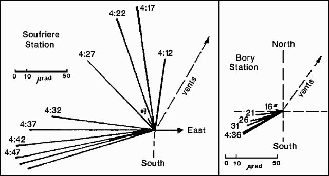 |
Figure 19. Progressive deformation recorded by the Soufrière and Bory tilt stations as the intrusion migrated from the summit region toward the eventual eruption fissures early 18 May 1988. Courtesy of OVPDLF. |
At 0433, fissures opened in four stages from 2,200 to 1,900 m altitude, E of the 7 November 1987 fissure vents (near von Drasche and Faujas Craters). The lower part of the fissures was initially very active, with large fountains of aphyric basalt emerging from a principal 300-m-long spatter rampart. Significant lava flows were extruded during the first 3 days of the eruption, and flow rates of up to 40 m3/s were observed. Lava production certainly exceeded 15 x 106 m3 during the first week, then flow rates declined to an average of 12 m3/s. The activity built a new cone, 25 m high, named Durandal (figure 20). Lava production from Durandal's crater stopped after 12 days, but lava continued to pour from tubes at the base of the cone (where there was a 10-m-high tumulus) advancing down the slopes of the Osmondes valley and accumulating as far as the base of the Piton de Crac, 3 km from the vent.
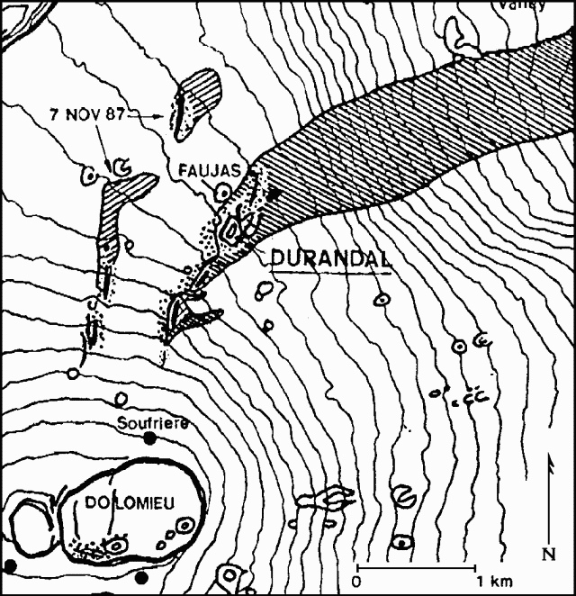 |
Figure 20. Sketch map showing part of the summit caldera of Piton de la Fournaise. The May 1988 and November 1987 lava flows are indicated by diagonal shading. Durandal Crater and fissure vents active in the 1988 eruption are shown with heavy lines. Courtesy of OVPDLF. |
Continuous E flank deflation had been recorded since the beginning of the eruption, with deformation returning progressively to its pre-eruption status. On 3 June deflation stopped; after a brief calm, a vent opened at the base of Durandal Crater, feeding a high-temperature lava flow. Activity was continuing as of 10 June, with the emission of a small degassed lava flow at a low rate, occasional tephra ejections, and significant sulfur degassing from Durandal Crater. Total lava production was estimated at around 30 x 106 m3, and the eruption was considered as one of the most important of the last 10 years.
Geological Summary. Piton de la Fournaise is a massive basaltic shield volcano on the French island of Réunion in the western Indian Ocean. Much of its more than 530,000-year history overlapped with eruptions of the deeply dissected Piton des Neiges shield volcano to the NW. Three scarps formed at about 250,000, 65,000, and less than 5,000 years ago by progressive eastward slumping, leaving caldera-sized embayments open to the E and SE. Numerous pyroclastic cones are present on the floor of the scarps and their outer flanks. Most recorded eruptions have originated from the summit and flanks of Dolomieu, a 400-m-high lava shield that has grown within the youngest scarp, which is about 9 km wide and about 13 km from the western wall to the ocean on the E side. More than 150 eruptions, most of which have produced fluid basaltic lava flows, have occurred since the 17th century. Only six eruptions, in 1708, 1774, 1776, 1800, 1977, and 1986, have originated from fissures outside the scarps.
Information Contacts: H. Delorme, D. Vandamme, P. Nerbusson, J. Delmond, and P. Taochi, OVPDLF; J. Dubois, J-L. Cheminée, A. Hirn, P. Blum, and J. Zlotnicki, IPGP ; P. Bachelery, Univ de la Réunion.