Report on Banda Api (Indonesia) — June 1988
Scientific Event Alert Network Bulletin, vol. 13, no. 6 (June 1988)
Managing Editor: Lindsay McClelland.
Banda Api (Indonesia) Steaming and seismicity; many evacuees return
Please cite this report as:
Global Volcanism Program, 1988. Report on Banda Api (Indonesia) (McClelland, L., ed.). Scientific Event Alert Network Bulletin, 13:6. Smithsonian Institution. https://doi.org/10.5479/si.GVP.SEAN198806-265090
Banda Api
Indonesia
4.523°S, 129.881°E; summit elev. 596 m
All times are local (unless otherwise noted)
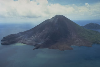
The violent ash explosions and vigorous lava production that began 9 May had subsided by mid-May (13:05). Activity had been concentrated at two vents on the N flank and at numerous vents on the S flank, along a fissure oriented NNE-SSW. Most of the 9.4 x 10⁶ m3 of lava was produced during the first 12-18 hours of the 9-15 May eruption. The flows in order of decreasing volume are: NW flank (Pasir Besar), N flank (Batu Angus), and the two S-flank flows. A persistent white steam plume rose 50 m above the summit vent during June. Approximately eight A-type and eight B-type earthquakes were recorded daily. VSI installed three additional seismometers, including two on Gunung Api.
Through May, a total of 7,000 residents had remained evacuated. On 13 June, VSI reassessed the volcanic activity and recommended that residents return to neighboring Banda Neira and Lontar islands. The 1,800 residents of Pulau Gunung Api remained evacuated to Ambon, Ceram, and Lontar Islands.
Further Reference. Casadevall, T., Pardyanto, L., Abas, H., and Tulus, 1989, The 1988 eruption of Banda Api volcano, Maluku, Indonesia: Geologi Indonesia, v. 12, n. 1, p. 603-635.
Geological Summary. The 3-km-wide island of Banda Api is the northern-most volcano in the Banda arc and has a long period of recorded observation because of its key location in the Portuguese and Dutch spice trade. The basaltic-to-rhyodacitic volcano is located in the SW corner of a mostly submerged 7 km caldera. At least two episodes of caldera formation are thought to have occurred, with the arcuate islands of Lonthor and Neira considered to be pre-caldera remnants. A conical peak rises to about 600 m at the center of the island. Eruptions have been recorded since 1586 CE, mostly consisting of Strombolian eruptions from the summit crater, but larger explosive eruptions have occurred and occasional lava flows have reached the coast.
Information Contacts: VSI.