Report on Dutton (United States) — July 1988
Scientific Event Alert Network Bulletin, vol. 13, no. 7 (July 1988)
Managing Editor: Lindsay McClelland.
Dutton (United States) Earthquake swarm
Please cite this report as:
Global Volcanism Program, 1988. Report on Dutton (United States) (McClelland, L., ed.). Scientific Event Alert Network Bulletin, 13:7. Smithsonian Institution. https://doi.org/10.5479/si.GVP.SEAN198807-312011
Dutton
United States
55.183°N, 162.276°W; summit elev. 1465 m
All times are local (unless otherwise noted)
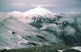
On 10 July, a swarm of small shallow earthquakes began SW of Mt. Dutton. Epicenters gradually migrated NW underneath the mountain's SW flank. The events were similar to a smaller swarm that occurred in 1984. On 15 July and 8 August, days of peak activity, earthquakes (M<=3.8) were felt in the King Cove and Cold Bay areas, ~13 km S and 28 km W of Mt. Dutton, respectively. No harmonic tremor or B-type events have been recorded, and geologists have been unable to determine whether the seismicity is related to magma migration or tectonic movement. During reconnaissance field investigations on 25 and 26 July, T. Miller observed no evidence of gas emission, melting snow, or other changes to the edifice, and no historical volcanic activity has been documented. Holocene activity is indicated by unglaciated pyroclastic deposits on the E flank, debris avalanches on the S flank, and a dome on the NE flank. No surface faults have been mapped with trends similar to current seismicity. Lamont-Doherty's pre-existing regional seismic network and two supplemental seismic stations recently installed on the volcano's slopes by the AVO were recording daily earthquake activity as of mid-August.
Geological Summary. The Mount Dutton volcanic center east of Cold Bay near the tip of the Alaska Peninsula consists of a glacier-covered central lava dome complex. Early andesitic lava flows and late-stage dacitic domes have been partially removed by one or more edifice collapses about 5100-6800 years ago. Debris avalanches traveled west and south, reaching Belkofski Bay. The important regional fishing center of King Cove lies less than 15 km from the volcano, and the village's airstrip is built on top of the southern avalanche deposit. A steep-sided complex of lava domes forms the summit, and young block-and-ash flow deposits extend to the east. Two small unglaciated lava domes on the NE flank 3.5 km from the summit are also of Holocene age. Major earthquake swarms near the volcano were recorded in 1984-85 and 1988.
Information Contacts: M.E. Yount and T. Miller, Branch of Alaskan Geology, USGS Anchorage; Klaus H. Jacob, Lamont-Doherty Geological Observatory, NY; J. Reeder, ADGGS; John Power, Univ of Alaska Geophysical Institute, Fairbanks.