Report on Bagana (Papua New Guinea) — November 1988
Scientific Event Alert Network Bulletin, vol. 13, no. 11 (November 1988)
Managing Editor: Lindsay McClelland.
Bagana (Papua New Guinea) Summit lava extrusion continues; seismic swarm
Please cite this report as:
Global Volcanism Program, 1988. Report on Bagana (Papua New Guinea) (McClelland, L., ed.). Scientific Event Alert Network Bulletin, 13:11. Smithsonian Institution. https://doi.org/10.5479/si.GVP.SEAN198811-255020
Bagana
Papua New Guinea
6.137°S, 155.196°E; summit elev. 1855 m
All times are local (unless otherwise noted)
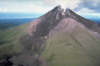
"Seismic activity continued at a steady low level until 7 November when a swarm of 1,500 small explosion-type earthquakes were recorded. Visual reports were obtained of red material sliding or rolling down the E slopes of the volcano on the 6th and pale brown dust/vapour rising from the same area on the 7th. Seismic activity then returned to a normal level with 15 rockfall-related tremor events/day, indicating continued slow steady extrusion of lava from the summit crater. Seismic telemetry to Rabaul stopped on the 14th. Records continued to be obtained at Panguna until the nearby Mt. Kupara repeater station, containing RVO telemetry equipment, was destroyed on 2 December."
Geological Summary. Bagana volcano, in a remote portion of central Bougainville Island, is frequently active. This massive symmetrical cone was largely constructed by an accumulation of viscous andesitic lava flows. The entire edifice could have been constructed in about 300 years at its present rate of lava production. Eruptive activity is characterized by non-explosive effusion of viscous lava that maintains a small lava dome in the summit crater, although occasional explosive activity produces pyroclastic flows. Lava flows with tongue-shaped lobes up to 50 m thick and prominent levees descend the flanks on all sides.
Information Contacts: I. Itikarai and P. Lowenstein, RVO.

