Report on Kie Besi (Indonesia) — November 1988
Scientific Event Alert Network Bulletin, vol. 13, no. 11 (November 1988)
Managing Editor: Lindsay McClelland.
Kie Besi (Indonesia) More details on July-August eruption
Please cite this report as:
Global Volcanism Program, 1988. Report on Kie Besi (Indonesia) (McClelland, L., ed.). Scientific Event Alert Network Bulletin, 13:11. Smithsonian Institution. https://doi.org/10.5479/si.GVP.SEAN198811-268070
Kie Besi
Indonesia
0.32°N, 127.4°E; summit elev. 1357 m
All times are local (unless otherwise noted)
. . . . The number of shallow volcanic earthquakes began to increase sharply on 20 July. Based on seismic and visual data, VSI anticipated that an eruption would begin within two weeks, and the 15,000 residents of Makian Island were evacuated to Moti Island, ~6 km to the N.
On 28 July, 521 seismic events were recorded, and tremor began . . . at 2200. The eruption started the next morning at 1112 with a continuous thunderous explosion that was clearly heard on Moti Island. A dark ash cloud reached 8-10 km height. On 30 July at 1006, an explosion was followed by nuées ardentes that advanced E (along the Ng. Powate valley) and N (Ng. Para valley). Originating from ~1,200 m asl, the nuées ardentes descended to 250 m altitude, and some finally reached the sea. A series of smaller explosions began on 31 July and continued until 6 August, feeding ash columns that decreased from 6 to 1-2 km above the crater.
As of the first week in December, white fume was still rising weakly from the crater. Seismicity continued to decrease, with 17 tectonic and 14 volcanic earthquakes recorded 1-7 December.
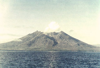
Geological Summary. Kie Besi volcano, forming the 10-km-wide Makian island off the west coast of Halmahera, has been the source of infrequent, but strong eruptions that have devastated villages on the island. The large 1.5-km-wide summit crater, containing a small lake on the NE side, gives the peak a flat-topped profile. Two prominent valleys extend to the coast from the summit crater on the north and east sides. Four cones are found on the western flanks. Eruption have been recorded since about 1550; major eruptions in 1646, 1760-61, 1861-62, 1890, and 1988 caused extensive damage and many fatalities.
Information Contacts: VSI.