Report on Long Valley (United States) — November 1988

Scientific Event Alert Network Bulletin, vol. 13, no. 11 (November 1988)
Managing Editor: Lindsay McClelland.
Long Valley (United States) Several hundred earthquakes in E caldera moat
Please cite this report as:
Global Volcanism Program, 1988. Report on Long Valley (United States) (McClelland, L., ed.). Scientific Event Alert Network Bulletin, 13:11. Smithsonian Institution. https://doi.org/10.5479/si.GVP.SEAN198811-323822
Long Valley
United States
37.7°N, 118.87°W; summit elev. 3390 m
All times are local (unless otherwise noted)
One of Long Valley caldera's more significant earthquake swarms of the last several years occurred 20-22 November (figure 4). Of the 393 recorded events (to M 2.0), most were located in the E moat of the caldera (near the E margin of the resurgent dome) with minor activity in the S moat (figure 5). The swarm trended N-S at depths of about 6 km. As the number of events/hour decreased, average magnitude increased. First order levelling surveys were completed across the epicentral area in 1986; about two weeks before the swarm; and the day after it began. The data suggested slight uplift of the area W of the epicentral zone relative to the E side, consistent with normal faulting, but the measured changes were within error limits (figure 6).
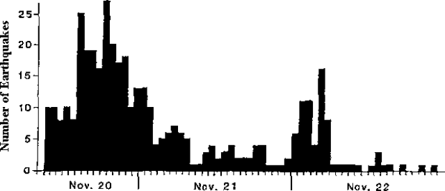 |
Figure 4. Number of events/hour measured at Long Valley caldera on station CNOC, 10 km from most epicenters (detection threshold about M 0). Courtesy of Stephen McNutt. |
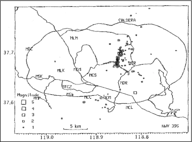 |
Figure 5. Epicenters of the 20-22 November Long Valley caldera earthquake swarm. Courtesy of John Estrem. |
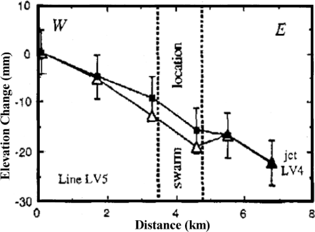 |
Figure 6. Preseismic (1986-88) and coseismic (1988-88) elevation changes across the epicentral area of the 20 November swarm at Long Valley caldera. Courtesy of John Estrem. |
Further Reference. Langbein, J., 1989, Deformation of the Long Valley Caldera, Eastern California, from mid-1983 to mid-1988; Measurements Using a Two-Color Geodimeter; Journal of Geophysical Research, v. 94, p. 3833-3849.
Geological Summary. The large 17 x 32 km Long Valley caldera east of the central Sierra Nevada Range formed as a result of the voluminous Bishop Tuff eruption about 760,000 years ago. Resurgent doming in the central part of the caldera occurred shortly afterwards, followed by rhyolitic eruptions from the caldera moat and the eruption of rhyodacite from outer ring fracture vents, ending about 50,000 years ago. During early resurgent doming the caldera was filled with a large lake that left strandlines on the caldera walls and the resurgent dome island; the lake eventually drained through the Owens River Gorge. The caldera remains thermally active, with many hot springs and fumaroles, and has had significant deformation, seismicity, and other unrest in recent years. The late-Pleistocene to Holocene Inyo Craters cut the NW topographic rim of the caldera, and along with Mammoth Mountain on the SW topographic rim, are west of the structural caldera and are chemically and tectonically distinct from the Long Valley magmatic system.
Information Contacts: S. McNutt, California Division of Mines and Geology, Sacramento; D. Hill, John Estrem, and James Savage, USGS Menlo Park.