Report on Siple (Antarctica) — December 1988
Scientific Event Alert Network Bulletin, vol. 13, no. 12 (December 1988)
Managing Editor: Lindsay McClelland.
Siple (Antarctica) Overflight shows no sign of recent eruption
Please cite this report as:
Global Volcanism Program, 1988. Report on Siple (Antarctica) (McClelland, L., ed.). Scientific Event Alert Network Bulletin, 13:12. Smithsonian Institution. https://doi.org/10.5479/si.GVP.SEAN198812-390025
Siple
Antarctica
73.43°S, 126.67°W; summit elev. 3110 m
All times are local (unless otherwise noted)
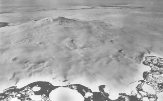
Further analysis of satellite images by geologists strongly suggested that the plumes originated from the volcano's summit, rather than its base. On 30 December, Philip Kyle and William McIntosh conducted an aerial inspection of the snow-covered volcano. The weather was clear except for low clouds below 500 m, around the mountain's base. No fresh ash, new craters, disruptions to the snowpack, or other evidence of recent explosive volcanism were observed. Although appearing identical to known eruption clouds, Kyle believes that the Mt. Siple plumes resulted from meteorological effects.
Geological Summary. Mount Siple is a shield volcano that forms an island along the Pacific Ocean coast of Antarctica's Marie Byrd Land. The massive 1,800 km3 volcano is truncated by a 4-5 km summit caldera and is ringed by tuff cones at sea level. A possible eruption cloud observed on satellite images on 18 September and 4 October 1988 was considered to result from atmospheric effects, after low-level aerial observations revealed no evidence of recent eruptions. Trachytic rocks at the summit have been Ar-Ar dated to about 227,000 and 169,000 years old.
Information Contacts: P. Kyle, New Mexico Institute of Mining & Technology.