Report on Tokachidake (Japan) — January 1989
Scientific Event Alert Network Bulletin, vol. 14, no. 1 (January 1989)
Managing Editor: Lindsay McClelland.
Tokachidake (Japan) Continued explosions (and partial evacuation)
Please cite this report as:
Global Volcanism Program, 1989. Report on Tokachidake (Japan) (McClelland, L., ed.). Scientific Event Alert Network Bulletin, 14:1. Smithsonian Institution. https://doi.org/10.5479/si.GVP.SEAN198901-285050
Tokachidake
Japan
43.418°N, 142.686°E; summit elev. 2077 m
All times are local (unless otherwise noted)
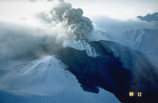
By 8 February, 20 eruptive episodes had occurred from crater 62-2 (figure 3). During January, crater 62-2 emitted steam with occasional small amounts of gray ash. Red glow from the crater was seen almost every night from JMA's Tokachi-dake Volcano Observatory. White plumes continuously rose a few tens of meters from craters 62-0 and 62-1. Red glow in Taisho Crater was often seen 8-14 January. Residents of the Shirogane area (6 km NW) have remained evacuated since the 24-25 December eruption.
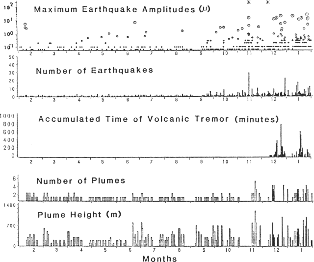 |
Figure 3. Summary of volcanic and seismic activity at Tokachi-dake, February 1988-January 1989. Courtesy of JMA. |
Seismicity was at a high level during the second half of January. A seismometer (4.5 km NNW of the volcano) registered 126 volcanic earthquakes during the month, an increase from 104 in December. Volcanic tremor episodes with amplitudes of about 0.1 µm were intermittently recorded by the same seismometer. An earthquake swarm, centered ~25 km E of the volcano, began on 14 January. Some of the events were felt at the observatory. The strongest had an intensity of III on 14 January.
The following is a summary of eruptive activity during the report period:
16 January at 1855: the eruption was accompanied by an earthquake felt at Intensity I at the Observatory. Ash fell as far E as Nukabira, 45 km away. Cloudy weather prevented plume observation. A field survey on 18 January revealed that a pyroclastic flow had advanced 1 km down the NW flank, along the same route as the mudflow caused by the 24-25 December eruption.
20 January, 0322: The eruption was accompanied by a weak explosion sound and incandescent column. Low-frequency volcanic tremor began 2 minutes before the eruption on the Hokkaido Univ seismometer at Hinangoya, 1 km ENE of the 1962 craters. Ash fell 30 km E of the volcano. A 900-m-high, grayish-white plume was seen from the Observatory at 0700.
[An explosion on 22 January is listed in 14:2].
24 January, 1224: The highest plume of the month reached 1,000 m above the crater.
28 January, 0518, 0611, and 0700: three explosions were accompanied by air shocks. Explosion sounds were heard at Shirogane hot spring, 6 km from the crater. Cloudy weather prevented plume observation. Slight ashfall was observed as far as 80 km SE of the volcano.
1 February, 1818: Low-frequency earthquakes were recorded at Hinangoya at 1700, preceding the eruption. Ash fell 70 km E.
4 February, 0038: Ash fell 100 km from the volcano.
[See 14:2 for explosions 6-7 February].
8 February, 0402: An eruption was accompanied by an explosion sound and incandescent column. A small pyroclastic flow descended from the crater.
Geological Summary. Tokachidake volcano consists of a group of dominantly andesitic stratovolcanoes and lava domes arranged on a NE-SW line above a plateau of welded Pleistocene tuffs in central Hokkaido. Numerous explosion craters and cinder cones are located on the upper flanks of the small stratovolcanoes, with the youngest Holocene centers located at the NW end of the chain. Frequent historical eruptions, consisting mostly of mild-to-moderate phreatic explosions, have been recorded since the mid-19th century. Two larger eruptions occurred in 1926 and 1962. Partial cone collapse of the western flank during the 1926 eruption produced a disastrous debris avalanche and mudflow.
Information Contacts: JMA.