Report on Pacaya (Guatemala) — February 1989

Scientific Event Alert Network Bulletin, vol. 14, no. 2 (February 1989)
Managing Editor: Lindsay McClelland.
Pacaya (Guatemala) Strong explosions; ashfall to coast; two flank lava flows
Please cite this report as:
Global Volcanism Program, 1989. Report on Pacaya (Guatemala) (McClelland, L., ed.). Scientific Event Alert Network Bulletin, 14:2. Smithsonian Institution. https://doi.org/10.5479/si.GVP.SEAN198902-342110
Pacaya
Guatemala
14.382°N, 90.601°W; summit elev. 2569 m
All times are local (unless otherwise noted)
Vigorous explosive activity from Pacaya 7-10 March deposited ash to the S coast (more than 50 km away), and lava flows advanced several kilometers from two flank vents. Activity at Pacaya in recent months had been characterized by moderate summit Strombolian activity and production of small lava flows from upper flank vents. About 1600 seismic events/day were recorded through most of February. A slight increase in seismicity was observed 25-27 February, and the number of events varied from 1700 to 2300, 28 February-6 March. A logarithmic increase began 7 March at about 0600, continuing until the onset of the main eruption at about 1300 (figures 4 and 5).
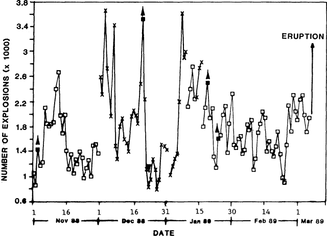 |
Figure 4. Estimate of the number of explosions/day from Pacaya, November 1988-7 March 1989. X's mark direct observations, squares indicate data from seismic recordings. Filled squares with arrows indicate the appearance of lava flows, with the downward-pointing arrow showing the time when feeding of flows stopped. Courtesy of INSIVUMEH. |
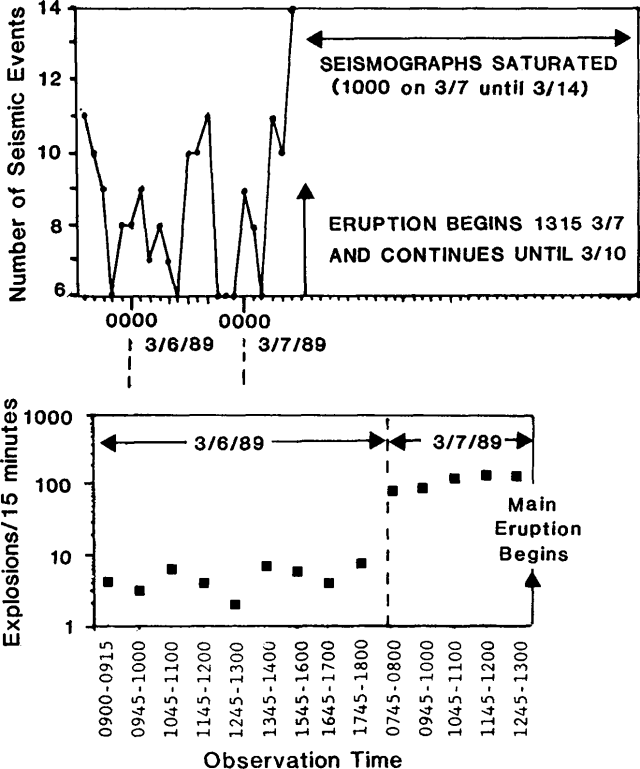 |
Figure 5. top Number of Pacaya's explosions counted from seismic records in a selected 15-minute interval every 2 hours, 5-7 March. bottom Visual observations of explosions during selected 15-minute intervals, 6 March until the onset of the eruption. Note that the y axis is logarithmic. Courtesy of INSIVUMEH. |
On 7 March at about 1030 Pacaya was erupting normally, with small Strombolian bursts every 2 minutes from MacKenney Cone. At around 1100, fumaroles on the E face of MacKenney were emitting about 5-10 times as much vapor as usual. A large white steam plume emerged from MacKenney Cone at about 1130 and was carried NE by the wind. Strombolian explosions had stopped. Explosions from MacKenney crater at about 1230 ejected a reddish-brown ash cloud, consisting of lithic fragments produced during crater enlargement, that rose about 1,000 m. At about 1300, MacKenney Cone began to erupt dense dark ash that rose 2,000-3,000 m above the vent and was carried NE. During the afternoon, incandescent tephra rose to an estimated sustained height of 2,000 m, punctuated by explosions that ejected black ash and block-sized tephra to 3,000 m above the crater. Sheet-like flows of incandescent material and other debris, apparently fed by column collapse, moved about 200 m down the upper flanks on all sides of the summit area, exhibiting serrated fronts. Light ashfall mixed with rain occurred at Cerro Grande, El Chipilinar, San Carlos, and Santa Elena Barillas (all within 7 km and NE of the crater). At 1930, light ashfall was reported in the Barberena and Cuilapa areas (30-35 km SE). Lapilli and ash began to fall in the El Caracol area (3.5 km SW of MacKenney crater) at 1945. Bombs and blocks as much as 1.5 m in diameter fell in the La Meseta area 1-1.5 km N of the vent, forming impact craters up to 3-4 m in diameter and 1-1.5 m deep. By 2000, the ash plume was rising 2,400 m above MacKenney crater. Small pyroclastic flows were observed at that time on the SW flank, descending to about 2,000 m elevation. Explosive activity declined after 2000 and no more pyroclastic flows were observed.
Between 1230 and 1245, Zurgen Philipp observed a bulge forming on the N flank at about 2,200 m elevation, about 20 m E of the post-1983 hornito on the somma floor. As vigorous ash emission began from MacKenney Cone at about 1300, lava broke out from the bulge and flowed W (figure 6), ponding to about 10 m depth on the somma floor before overflowing toward the town of El Patrocinio (3.5 km W of the summit). At least two more vents opened at about 1,900 m elevation between Pacaya and Cerro Chino, contributing lava to the flow. Five lobes of aa, 2-3 m thick, advanced along a front about 0.4 km wide at a mean velocity of 20 m/hour. The flow burned trees and young coffee plants along its N side and cut a small road, but did not approach any houses. By 2000, the flow was ~ 1 km E of El Patrocinio and was moving W at 4-7 m/hour. Temperature measurements by thermocouple on 7 and 8 March yielded flow temperatures that varied between 860° and 1,018°C. The Comité Nacional de Emergencia and INSIVUMEH evacuated the 120 residents of El Caracol. Evacuation of El Patrocinio (population 900) was considered, but the flow's rate of advance had slowed to about 1 m/hour by 1500 on 8 March and officials decided not to require its evacuation. The Comité de Reconstrucción Nacional is relocating the people of El Caracol to a new village site.
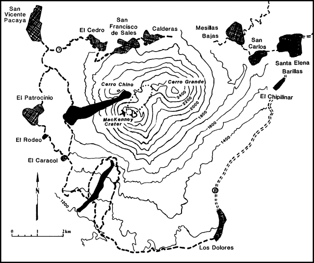 |
Figure 6. Sketch map of Pacaya and nearby towns. The approximate position of lava flows is shown in black, and distribution of bomb and block impact craters is indicated by the dotted area extending NE from MacKenney crater. Contour interval, 100 m. Contours around MacKenney crater are approximate. Roads are shown by dashed lines. Courtesy of INSIVUMEH. |
On 8 March at about 0815, activity increased again. Explosions from MacKenney crater fed an ash cloud that rose 1,000-3,000 m above the crater. Strong winds carried the cloud SW over El Caracol toward Escuintla (20 km from Pacaya). For 3-4 hours during the afternoon of 8 March, summit tephra production declined to moderate Strombolian explosions typical of Pacaya's long-term activity. Then lava fountaining, accompanied by increased seismicity, resumed over a period of hours in late afternoon when loud explosions were heard at a rate of about 20/minute. Activity decreased slightly early 9 March, but summit fountaining, explosions, and felt detonations continued. A column of sand- to block-sized tephra rose continuously from the crater to about 2,000 m height. Light ashfall on the S coast and near the Guatemala-El Salvador border (more than 80 km from Pacaya) was reported 9 March. Ash eruptions and strong NE winds persisted through 10 March, but activity had ended by the morning of 11 March.
A second lava flow began to emerge from a vent at 1,500 m altitude on the SW flank on 9 March at 1515. By 1930, the flow had moved about 1 km SW, and by 1640 the next day its front had reached 1260 m elevation while continuing to advance at 7 m/hour. The flow had reached 1220 m elevation by noon on 11 March, but was moving at less than 1 m/hour, and by 12 March it had stagnated. The flow cut a road and water line but did not reach inhabited areas.
During the eruption, about 75 m of the summit of MacKenney Cone was destroyed (figure 7). The crater's diameter was enlarged from 50-75 m before the eruption to an elliptical crater with horizontal dimensions of about 200 x 300-350 m. After the eruption, the crater floor was about 50 m below the rim. A single vent on the E end of the crater floor produced a strong white gas plume that rose several hundred meters.
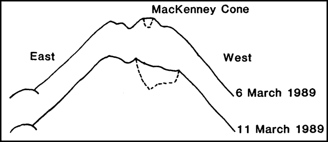 |
Figure 7. Profile of Pacaya looking south from Cerro Chino on 6 and 11 March, showing the changed morphology of MacKenney Cone. Courtesy of INSIVUMEH and the Univ of Puget Sound. |
Images of the eruption from NOAA's GOES satellite were obtained starting 9 March at 1800 (table 1). The plume extended roughly WSW-SW to 20 km off the Guatemala coast and was at least 3000 m high. On 10 March, surface winds blew the lower part of the plume S, while upper level winds (3000-5500 m altitude) carried the upper portions of the plume to the SW. At about 1300 the plume appeared to separate from the volcano. No plume was evident 11-13 March.
Table 1. Summary of Pacaya plume data from the GOES geostationary weather satellite, 9-10 March 1989. Courtesy of NOAA/NESDIS.
| Date | Time | Comments |
| 09 Mar 1989 | 1800-2100 | Plume extends WSW to ~20 km off the SW Guatemalan coast. |
| 10 Mar 1989 | 0600 | Lower part of plume extends S while higher altitude portion extends SW. |
| 10 Mar 1989 | 0600-0800 | Leading edge of plume just off the central coast of Guatemala. |
| 10 Mar 1989 | 1130 | Plume extends 180 km SW. Cloud top temperature of 7°C corresponds to altitude of 3,000 m. |
| 10 Mar 1989 | 1230-1300 | Plume seems to be separating from volcano. |
| 10 Mar 1989 | 1300-1400 | Definite separation from volcano. |
Geological Summary. Eruptions from Pacaya are frequently visible from Guatemala City, the nation's capital. This complex basaltic volcano was constructed just outside the southern topographic rim of the 14 x 16 km Pleistocene Amatitlán caldera. A cluster of dacitic lava domes occupies the southern caldera floor. The post-caldera Pacaya massif includes the older Pacaya Viejo and Cerro Grande stratovolcanoes and the currently active Mackenney stratovolcano. Collapse of Pacaya Viejo between 600 and 1,500 years ago produced a debris-avalanche deposit that extends 25 km onto the Pacific coastal plain and left an arcuate scarp inside which the modern Pacaya volcano (Mackenney cone) grew. The NW-flank Cerro Chino crater was last active in the 19th century. During the past several decades, activity has consisted of frequent Strombolian eruptions with intermittent lava flow extrusion that has partially filled in the caldera moat and covered the flanks of Mackenney cone, punctuated by occasional larger explosive eruptions that partially destroy the summit.
Information Contacts: E. Sánchez (Subdirector General); Otoniel Matías, Enrique Molina, Roberto Solís, Rodolfo Morales, and Jorge Girón, INSIVUMEH; Zurgen Philipp, Antigua, Guatemala; Albert Eggers and Keith Brunstad, Univ of Puget Sound, USA; Michael Doukas, USGS; Sheldon Kusselson and Otto Karst, SAB.