Report on Lonquimay (Chile) — March 1989
Scientific Event Alert Network Bulletin, vol. 14, no. 3 (March 1989)
Managing Editor: Lindsay McClelland.
Lonquimay (Chile) Lava production exceeds 108 m3; tephra emission continues
Please cite this report as:
Global Volcanism Program, 1989. Report on Lonquimay (Chile) (McClelland, L., ed.). Scientific Event Alert Network Bulletin, 14:3. Smithsonian Institution. https://doi.org/10.5479/si.GVP.SEAN198903-357100
Lonquimay
Chile
38.379°S, 71.586°W; summit elev. 2832 m
All times are local (unless otherwise noted)
Moderate ash emission and lava production were continuing in mid-April from Navidad cone. Increased seismicity had preceded the onset of more vigorous tephra emission on 24 February and activity remained strong into early March (figure 9). As of early April, ash clouds were rising to 3-4 km altitude. Most ash fell E of the volcano. The rate of lava production peaked 2-7 January at an estimated 75 m3/s, then declined, but was increasing slightly in late March (table 6). By 25 March, after 90 days of activity, the lava flow volume was estimated at 1.03 x 10⁸ m3, and it had advanced 10 km down the Lolco river valley (figure 10).
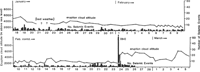 |
Figure 9. Altitudes reached by tephra clouds from Navidad cone (curve) and number of seismic events in 4-hour periods (bars), 18 January-5 March 1989. Courtesy of O. González-Ferrán. |
Table 6. Estimated dimensions, volume, extrusion rate, and flow front velocity of the andesitic block lava from Navidad crater, 25 December 1988-25 March 1989. Courtesy of O. González-Ferrán.
| Date | Days | Length (m) | Width (m) | Volume (x 106 m3) | Rate (m3/s) | Velocity (m/hour) |
| 25 Dec-27 Dec 1988 | 2 | 500 | 200 | 0.5 | 3 | 11 |
| 27 Dec-02 Jan 1989 | 6 | 3000 | 500 | 15 | 30 | 21 |
| 02 Jan-03 Jan 1989 | 1 | 1300 | 500 | 6.5 | 75 | 54 |
| 03 Jan-07 Jan 1989 | 4 | -- | -- | 25.8 | 75 | -- |
| - Flow 1 | -- | 1400 | 400 | 5.6 | -- | 15 |
| - Flow 2 | -- | 900 | 1500 | 4.8 | -- | 9 |
| - Flow 3 | -- | 1000 | 1100 | 15.4 | -- | 10 |
| 07 Jan-26 Jan 1989 | 19 | 2000 | 800 | 24 | 15 | 4 |
| 26 Jan-02 Feb 1989 | 7 | 800 | 320 | 5.12 | 8 | 5 |
| 02 Feb-12 Feb 1989 | 10 | 800 | 250 | 5 | 6 | 3 |
| 12 Feb-10 Mar 1989 | 26 | 800 | 300 | 7.2 | 3 | 1 |
| 10 Mar-25 Mar 1989 | 15 | 900 | 600 | 13.5 | 11 | 3 |
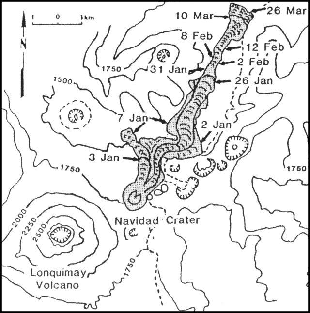 |
Figure 10. Sketch map showing the advance of the lava flow, 25 December 1988-26 March 1989. Courtesy of O. González-Ferrán, H. Moreno, and P. Riffo. |
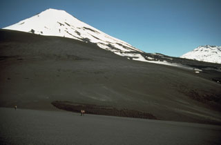
Navidad cone, an asymmetric pyroclastic cone composed of black scoria with a minor amount of spatter-like bombs, was 210 m high and 700 m in E-W basal diameter in early April. It remained horseshoe-shaped, breached to the N. The crater was funnel-shaped and elongated NNE, with a minimum diameter of 250 m NW-SE. At its eastern base were 3-4 vents, one of which was continuously active. As viewed from the S, the cone changed in shape from uniform slopes with a higher W rim, to an irregular E slope with a bulge close to the top and a higher E rim.
During early April, the eruption column varied between 500 and 1,500 m above the crater. Strong WNW winds dispersed the plume eastward to the Lonquimay District. Geologists estimated that the VEI has decreased to 1-2, from 2-3 in early January. Two conspicuous eruptive phases were observed in alternate periods of 10 to 90 minutes; a phreatic, strongly explosive one accompanied by a white to pale-brownish small ash/steam column, and a noiseless, voluminous, dark gray-brownish, tephra-rich column associated with deeper degassing and fragmentation.
Black scoria and dark gray ash have been deposited mainly E of the cone. Bombs of various shapes and sizes have been observed as far as 1 km NE of the vent, where they occasionally reached 2.5 m across. S and E of the cone the bombs fell closer, <200 m from its base. Ribbon, spindle, spatter, and minor cow-dung bombs were also observed.
By 5 April, the lava flow had two well-defined lobes. The longer was advancing along the Lolco river valley. The shorter, quite active, lobe was a new one moving NW on top of a flow from early in the eruption (Laguna Verde). The Lolco front reached 35 m height, and had a temperature of 1,040°C. It was advancing over a swampy area, causing soil deformation, squeezing the soft sediments, and contaminating the water of the Lolco river. Nearly 0.8 km2 of wild Araucaria forest have been destroyed along this valley. By early April, the lava flow covered an area of ~9.5 km2. Locally, the rough lava surface shows yellowish iron chlorides due to the high HCl content of the volcanic gases. SO2 has also been detected.
Geological Summary. Lonquimay is a small, flat-topped, symmetrical stratovolcano of late-Pleistocene to dominantly Holocene age immediately SE of Tolguaca volcano. A glacier fills its summit crater and flows down the S flank. It is dominantly andesitic, but basalt and dacite are also found. The prominent NE-SW Cordón Fissural Oriental fissure zone cuts across the entire volcano. A series of NE-flank vents and scoria cones were built along an E-W fissure, some of which have been the source of voluminous lava flows, including those during 1887-90 and 1988-90, that extended out to 10 km.
Information Contacts: O. González-Ferrán, Univ de Chile; H. Moreno, Univ de Chile; M. Gardeweg and J. Naranjo, SERNAGEOMIN, Santiago.