Report on Agua de Pau (Portugal) — March 1989
Scientific Event Alert Network Bulletin, vol. 14, no. 3 (March 1989)
Managing Editor: Lindsay McClelland.
Agua de Pau (Portugal) Seismicity since May 1988 summarized
Please cite this report as:
Global Volcanism Program, 1989. Report on Agua de Pau (Portugal) (McClelland, L., ed.). Scientific Event Alert Network Bulletin, 14:3. Smithsonian Institution. https://doi.org/10.5479/si.GVP.SEAN198903-382090
Agua de Pau
Portugal
37.77°N, 25.47°W; summit elev. 947 m
All times are local (unless otherwise noted)
[Agua de Pau information only; extracted from a summary of significant seismic activity in the E Azores (figure 1) since May 1988.]
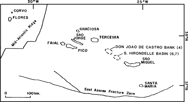 |
Figure 1. Sketch map showing islands in the eastern Azores. Approximate epicenters of the 3-5 October 1988 swarm at the submarine volcano Don Joao de Castro Bank (4) and the 21 November 1988 and 21 January 1989 earthquakes in the Hirondelle Basin (6 and 7) are shown. Courtesy of R. Moore. |
"A swarm of microearthquakes, accompanied by weak harmonic tremor, occurred beneath the NE flank of Agua de Pau Volcano on Sao Miguel (figure 2, zone 1) 23-24 May 1988. Seismometers recorded 383 earthquakes; the largest had intensities of MM IV-V in villages along the N coast. A similar but smaller swarm occurred in the same area in 1983 and was recorded by USGS seismographs. Numerous, small, normal faults (including some that show scissor-type movement) displace basaltic, tristanitic, and trachytic vent deposits and flows in this area. However, the area has had no eruptions for about 3,000 years and is the least active of the five volcanic zones on Sao Miguel that have erupted during Holocene time.
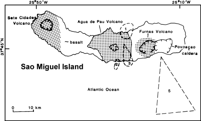 |
Figure 2. Approximate epicenters for earthquakes on and near the island of Sao Miguel, May-October, 1988. Courtesy of R. Moore. |
"A small swarm of microearthquakes occurred 24-26 June [1988] on the S flank of Agua de Pau Volcano (zone 2). Sixty-four earthquakes were recorded; the largest had intensities of MM III-IV in nearby villages. No tremor accompanied this episode.
"A small swarm of microearthquakes occurred 6 July [1988] near the S coast of Sao Miguel (zone 3). Fifty-one earthquakes were recorded; the largest was felt and had an intensity of MM III-IV. No tremor accompanied this episode.
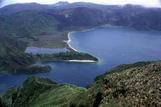
Geological Summary. The Agua de Pau stratovolcano in central Sao Miguel Island contains an outer 4 x 7 km caldera formed about 30,000-45,000 years ago and an inner 2.5 x 3 km caldera that was created about 15,000 years ago. The younger caldera is partially filled by the Lagoa do Fogo caldera lake. Several post-caldera lava domes were emplaced on the northern and western flanks, but activity in the caldera did not resume until about 5000 years ago. The 3 km3 Fogo-A plinian pumice fall deposit was emplaced at this time. Numerous flank cinder cones mark radial and concentric fissures, some of which have been active during historical time. The latest trachytic explosive eruption took place during 1563. Prominent hot springs are located on the NW flank.
Information Contacts: A. Rodrigues da Silva, Consorcio Geotermico de S. Miguel; R. Moore, USGS; National Institute of Meteorology and Geophysics, Portugal.