Report on Nyamulagira (DR Congo) — April 1989
Scientific Event Alert Network Bulletin, vol. 14, no. 4 (April 1989)
Managing Editor: Lindsay McClelland.
Nyamulagira (DR Congo) Lava erupts from summit and E flank
Please cite this report as:
Global Volcanism Program, 1989. Report on Nyamulagira (DR Congo) (McClelland, L., ed.). Scientific Event Alert Network Bulletin, 14:4. Smithsonian Institution. https://doi.org/10.5479/si.GVP.SEAN198904-223020
Nyamulagira
DR Congo
1.408°S, 29.2°E; summit elev. 3058 m
All times are local (unless otherwise noted)
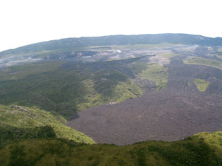
An eruption that began on 23 April in Nyamuragira's summit crater was reported by the Vice Conservator of the Institut Zairois pour la Conservation de la Nature, Parc National des Virunga. On the 24th at 1418, three lava fountains emerged from a fissure on the SSE flank of the volcano. Incandescence was visible from the village of Gisenyi, Rwanda, roughly 30 km from the vent. The resulting lava flow passed between Kitazungurwa and Rugarambiro cones, diverted around Gitebe cone, and flowed along lava erupted in 1981-82 from Rugarambiro (figure 6). By the 26th, the flow had reached Nyasheke-South and was ~6 km from Kakomero, the base camp for climbers at the park entrance.
On the night of the 26th, lava emerged from the W side of the Kanamaharagi cone (formed during the 1905 eruption), building a new parasitic cone (also named Kanamaharagi) at ~1,860 m altitude. Lava fountains up to 200 m high and large amounts of tephra were emitted 30 April-1 May. As of 6 May, the volcano was still erupting.
Geological Summary. Africa's most active volcano, Nyamulagira (also known as Nyamuragira), is a massive high-potassium basaltic shield about 25 km N of Lake Kivu and 13 km NNW of the steep-sided Nyiragongo volcano. The summit is truncated by a small 2 x 2.3 km caldera that has walls up to about 100 m high. Documented eruptions have occurred within the summit caldera, as well as from the numerous flank fissures and cinder cones. A lava lake in the summit crater, active since at least 1921, drained in 1938, at the time of a major flank eruption. Recent lava flows extend down the flanks more than 30 km from the summit as far as Lake Kivu; extensive lava flows from this volcano have covered 1,500 km2 of the western branch of the East African Rift.
Information Contacts: S. Peyer and H. Peyer, Gisenyi, Rwanda; H-L. Hody, GEOVAR, Kigali, Rwanda.

