Report on Lonquimay (Chile) — April 1989
Scientific Event Alert Network Bulletin, vol. 14, no. 4 (April 1989)
Managing Editor: Lindsay McClelland.
Lonquimay (Chile) Continued tephra emission; cattle sickened by ash
Please cite this report as:
Global Volcanism Program, 1989. Report on Lonquimay (Chile) (McClelland, L., ed.). Scientific Event Alert Network Bulletin, 14:4. Smithsonian Institution. https://doi.org/10.5479/si.GVP.SEAN198904-357100
Lonquimay
Chile
38.379°S, 71.586°W; summit elev. 2832 m
All times are local (unless otherwise noted)
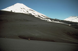
The eruption . . . was continuing in early May. Eruption clouds in April and early May, composed mainly of dark brown ash and water vapor, rose 500-1,500 m from Navidad Crater. The number of recorded seismic events had declined to 2-3/day.
Estimates of the volume of the lava flow vary, and are made difficult by the flow's very irregular thickness, which has been increasing faster than the area covered by lava. Hugo Moreno estimated that through March ~150 x 106 m3 of lava had been extruded. The lava flow's W lobe essentially stopped advancing in mid-February, but the E front continued to move down the Lolco River valley. Little additional advance of the lava flow was noted in April and early May. The position of the flow as of 5 April is shown in figure 11.
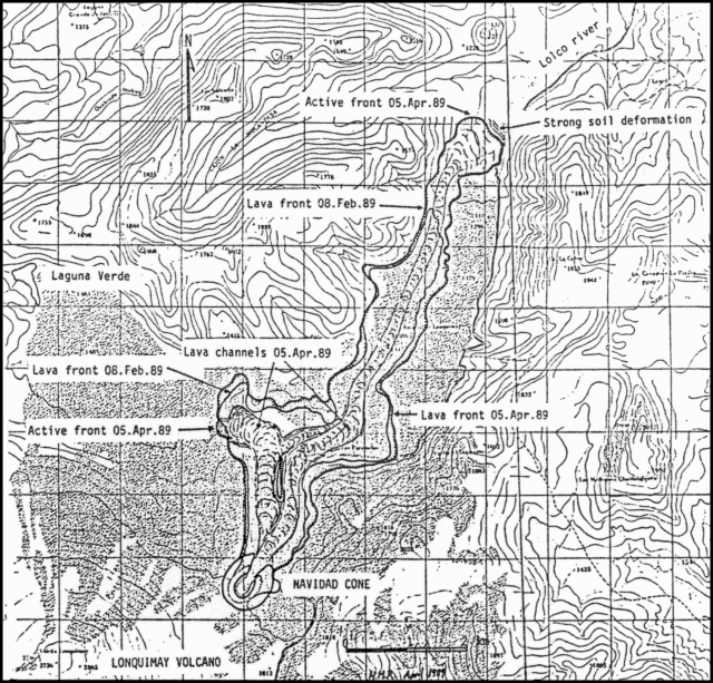 |
Figure 11. Map showing the lava flows as of 5 April 1989. Courtesy of Hugo Moreno Roa. |
About 10,000 cattle have been suffering the effects of ashfall since December. Many have lost >100 kg in weight and are dying. Analyses by specialists at the Univ Austral determined that the animals are being affected by overdoses of fluorine from the ash. Ash has fallen in various directions (see table 5). The localities most affected are Maillin del Treile, El Naranjo (both roughly 20 km ESE of the active crater), and Comunidad Bernardo Nanco, home to about 80 families, the majority of which depend for their livelihoods on animal raising. Losses are estimated at about $2,000,000 (US). Local authorities and the Ministries of Agriculture and Health are taking emergency measures. Forest fires have burned valuable native trees, including coigüe (Nothfogus dombeyi) and araucaria (Araucaria araucana).
Geological Summary. Lonquimay is a small, flat-topped, symmetrical stratovolcano of late-Pleistocene to dominantly Holocene age immediately SE of Tolguaca volcano. A glacier fills its summit crater and flows down the S flank. It is dominantly andesitic, but basalt and dacite are also found. The prominent NE-SW Cordón Fissural Oriental fissure zone cuts across the entire volcano. A series of NE-flank vents and scoria cones were built along an E-W fissure, some of which have been the source of voluminous lava flows, including those during 1887-90 and 1988-90, that extended out to 10 km.
Information Contacts: O. González-Ferrán, Univ de Chile; G. Fuentealba and P. Riffo, Univ de la Frontera; H. Moreno, Univ de Chile.