Report on Raung (Indonesia) — May 1989
Scientific Event Alert Network Bulletin, vol. 14, no. 5 (May 1989)
Managing Editor: Lindsay McClelland.
Raung (Indonesia) Strombolian activity and seismicity
Please cite this report as:
Global Volcanism Program, 1989. Report on Raung (Indonesia) (McClelland, L., ed.). Scientific Event Alert Network Bulletin, 14:5. Smithsonian Institution. https://doi.org/10.5479/si.GVP.SEAN198905-263340
Raung
Indonesia
8.119°S, 114.056°E; summit elev. 3260 m
All times are local (unless otherwise noted)
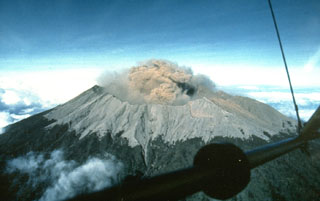
Strombolian activity in the bottom of the crater was photographed by Michel Halbwach (Univ of Savoie, France) in July/August 1988, during overflights in an ultralight aircraft arranged in cooperation with the Federation Aerosport of Indonesia (FASI). Activity was continuing in March, when brownish plumes that rose 100-150 m above the summit were seen 41 times. Recorded March seismicity included: 1,771 episodes of volcanic tremor and plume emission tremor, 90 strong tectonic earthquakes, one local tectonic earthquake, and one A-type and 11 B-type volcanic earthquakes.
Additional aerial monitoring of activity at Raung and other volcanoes has been proposed by FASI and VSI.
Geological Summary. Raung, one of Java's most active volcanoes, is a massive stratovolcano in easternmost Java that was constructed SW of the rim of Ijen caldera. The unvegetated summit is truncated by a dramatic steep-walled, 2-km-wide caldera that has been the site of frequent historical eruptions. A prehistoric collapse of Gunung Gadung on the W flank produced a large debris avalanche that traveled 79 km, reaching nearly to the Indian Ocean. Raung contains several centers constructed along a NE-SW line, with Gunung Suket and Gunung Gadung stratovolcanoes being located to the NE and W, respectively.
Information Contacts: VSI.

