Report on Eldey (Iceland) — May 1989

Scientific Event Alert Network Bulletin, vol. 14, no. 5 (May 1989)
Managing Editor: Lindsay McClelland.
Eldey (Iceland) Possible submarine volcanism
Please cite this report as:
Global Volcanism Program, 1989. Report on Eldey (Iceland) (McClelland, L., ed.). Scientific Event Alert Network Bulletin, 14:5. Smithsonian Institution. https://doi.org/10.5479/si.GVP.SEAN198905-371022
Eldey
Iceland
63.733°N, 23°W; summit elev. 70 m
All times are local (unless otherwise noted)
An earthquake swarm began shortly before midnight on 21 May, 500-550 km SW of the tip of Iceland's Reykjanes Peninsula. The most vigorous activity occurred between about 0200 and 0600 on [22] May, when 45 events were recorded on seismographs in SW Iceland (figure 1). Preliminary WWSSN data yielded locations for 22 events (M >= about 4.5) in the range 59.9-60.1°N, 29.6-29.9°W. The largest (4.9 mb/4.6 Ms) and best-located, on 22 May at 0202, was centered at 59.94°N, 29.90°W. The events were shallow, but no precise focal depths could be determined. The ridge crest in the area is at roughly 1 km depth. Seismologists noted that the long-period character of the seismicity suggested that it was related to magma movement, associated with an intrusive episode or an eruption onto the sea floor. No T-Phase signals were detected.
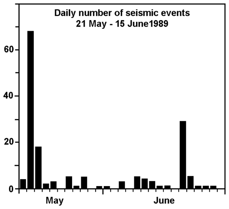 |
Figure 1. Number of earthquakes/day along the Reykjanes Ridge near 60°N, 21 May-15 June 1989. Courtesy of Páll Einarsson. |
Low-level seismicity continued for the next 2.5 weeks, then a new swarm began on 11 June, when 29 earthquakes were detected on SW Iceland seismographs. On 13 June, a reconaissance aircraft dropped sonobuoys into the ocean and took thermal profiles (with XBT's) in the epicentral area. No thermal anomalies were detected. The sonobuoys recorded 140 discrete events during 4 hours of monitoring, and locations were refined to 59.73°N, 29.53°W ± 3 km, on the ridge axis. Although seismic stations in Iceland had recorded more than 100 shocks since activity resumed on 11 June, none of the events during the aerial monitoring were strong enough to be detected in Iceland. Further flights are anticipated that may better define the location and character of the activity.
Geological Summary. The Eldey volcanic system is located on the northernmost part of the Reykjanes Ridge and is submarine with the exception of Eldey Island and the skerries (small rocky islands) Eldeyjardrangur, Geirfugladrangur, and Geirfuglasker. Maximum water depth within the system is about 250 m. Characteristic activity consists of explosive submarine basaltic eruptions. Six small eruptions have been located within this system during the last 1,100 years, the last occurring in 1926 CE. Bulletin reports that are included here cover a larger area of the Reykjanes Ridge south of Iceland without a clear source or enough evidence for a separate volcano entry.
Information Contacts: R. Stefánsson, Icelandic Meteorological Office; P. Einarsson, Univ of Iceland; R. Holcomb, Univ of Washington; B. Presgrave, NEIC; P. Vogt, Naval Research Laboratory.