Report on St. Helens (United States) — August 1989
Scientific Event Alert Network Bulletin, vol. 14, no. 8 (August 1989)
Managing Editor: Lindsay McClelland.
St. Helens (United States) Small earthquake swarms SW of the summit dome
Please cite this report as:
Global Volcanism Program, 1989. Report on St. Helens (United States) (McClelland, L., ed.). Scientific Event Alert Network Bulletin, 14:8. Smithsonian Institution. https://doi.org/10.5479/si.GVP.SEAN198908-321050
St. Helens
United States
46.2°N, 122.18°W; summit elev. 2549 m
All times are local (unless otherwise noted)
Activity at Mt. St. Helens has generally remained at background levels since a new lobe was added to the composite lava dome in October 1986 (SEAN 11:09 and 11:10). Some small seismic events have continued beneath the crater, but there has been no significant deformation and rates of SO2 emission have remained low.
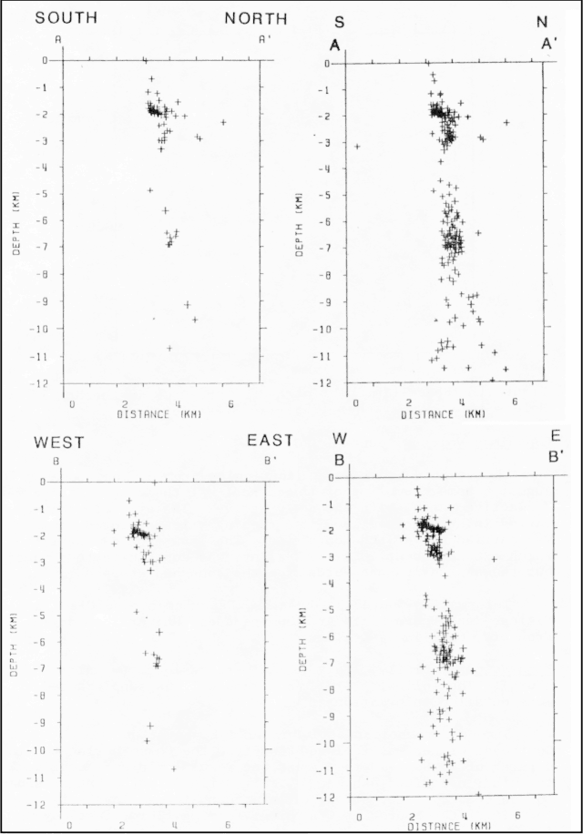
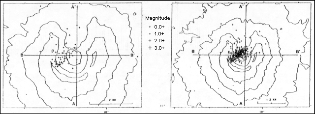
The first of three small bursts of recent seismicity began at 2227 on 24 August 1989 with an event similar to those associated with earlier gas-and-ash emission episodes, last documented in 1986. The initial event had a coda length of 95 seconds consisting of signals from two or more earthquakes, yielding a coda magnitude of roughly 2.7. Numerous small earthquakes saturated a seismic station (GDN) ~700 m N of the dome's center during the next half-hour, and roughly 300-500 individual events could be recognized on its record in the succeeding 4 hours. Another station (HOA) 5 km to the N was saturated (amplitude >68 mm peak to peak) for 15 seconds. Most of the events were centered SW of the dome along an extension of a NE-SW zone defined by earthquakes of the past 9 months (figure 36). The mean focal depth of the 16 best-located shocks was 1.8 plus or minus 0.18 km (figures 37 and 38). A somewhat smaller emission-like event occurred the next morning at 0918, followed by a period of increased background noise and small earthquakes. However, fewer than two dozen events were recorded during the next several hours. None of the 25 August seismicity saturated instruments; amplitudes reached only 7 mm at HOA station. A third emission-like event occurred 30 August at 1758. Crater seismic stations were saturated for 10-30 seconds, while maximum amplitude at HOA station was 19 mm peak to peak. Small earthquakes again followed the initial event, but fewer than a dozen could be recognized on records from the nearby GDN station. Seismic noise remained above background for ~2 hours.
 |
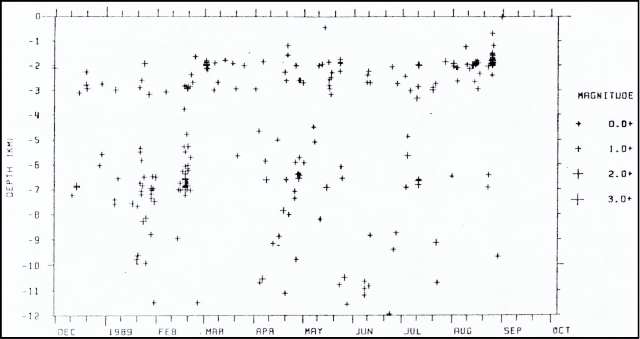
Figure 37. Space-time plot of earthquake foci recorded by the USGS in the Mt. St. Helens area, 30 November 1988-31 August 1989. Courtesy of E. Endo. |
Fieldwork following the seismicity did not reveal any evidence of associated eruptive activity. Seismologists suggested that the activity may have reflected the movement of volatiles (gas and/or liquid phase) a short distance SW from the conduit system beneath the crater.
Geological Summary. Prior to 1980, Mount St. Helens was a conical volcano sometimes known as the Fujisan of America. During the 1980 eruption the upper 400 m of the summit was removed by slope failure, leaving a 2 x 3.5 km breached crater now partially filled by a lava dome. There have been nine major eruptive periods beginning about 40-50,000 years ago, and it has been the most active volcano in the Cascade Range during the Holocene. Prior to 2,200 years ago, tephra, lava domes, and pyroclastic flows were erupted, forming the older edifice, but few lava flows extended beyond the base of the volcano. The modern edifice consists of basaltic as well as andesitic and dacitic products from summit and flank vents. Eruptions in the 19th century originated from the Goat Rocks area on the N flank, and were witnessed by early settlers.
Information Contacts: E. Endo, CVO.


