Report on Nevado del Ruiz (Colombia) — August 1989

Scientific Event Alert Network Bulletin, vol. 14, no. 8 (August 1989)
Managing Editor: Lindsay McClelland.
Nevado del Ruiz (Colombia) Phreatomagmatic eruption; mudflow destroys bridge
Please cite this report as:
Global Volcanism Program, 1989. Report on Nevado del Ruiz (Colombia) (McClelland, L., ed.). Scientific Event Alert Network Bulletin, 14:8. Smithsonian Institution. https://doi.org/10.5479/si.GVP.SEAN198908-351020
Nevado del Ruiz
Colombia
4.892°N, 75.324°W; summit elev. 5279 m
All times are local (unless otherwise noted)
Increased seismicity since mid-August was followed on 1 September by a summit phreatomagmatic eruption that deposited tephra NE of the crater and generated a damaging mudflow.
Vigorous earthquake activity was recorded during August, with numerous A-and B-type events, continuing a trend of increased seismicity that began about February 1988. The month's strongest high-frequency seismic energy release was on 19 August, from a swarm of events centered S of Arenas Crater (figure 29), the main vent of the fatal 1985 eruption. The rate of SO2 emission generally increased in August, oscillating between 416 and 3,800 t/d, for an average of 1,762 t/d (figure 30). Little change was noted in August dry-tilt data and no major changes were detected by electronic tilt instruments. However, the N-S component of the Refugio tilt station (2.3 km WNW of Arenas Crater) has shown a gradual inflationary trend since May 1987 that totaled ~64 µrad by the end of August 1989; the E-W component has registered only minor fluctuations (figure 31).
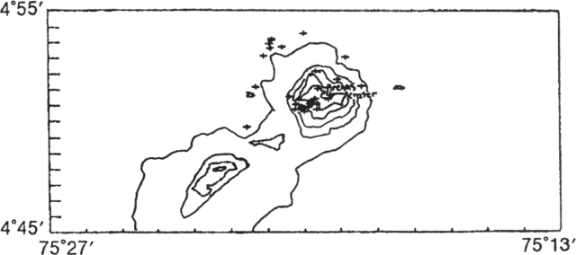 |
Figure 29. Epicenters of 35 high-frequency earthquakes near Ruiz, August 1989. Courtesy of the Observatorio Vulcanológico de Colombia. |
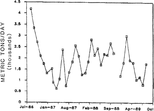 |
Figure 30. Monthly means of rates of SO2 emission measured by COSPEC at Ruiz, July 1986-August 1989. Courtesy of the Observatorio Vulcanológico de Colombia. |
 |
Figure 31. N-S (top) and E-W (bottom) components of electronic tilt recorded at the Refugio station, March 1987-August 1989. Courtesy of the Observatorio Vulcanológico de Colombia. |
Long-period earthquakes increased sharply in the week before the eruption. Tremor (3 mm peak to peak) began late 30 August, associated with ash emission, and ash was emitted again the next day. COSPEC SO2 data provided no obvious short-term warning, with measurements ~18 hours before the eruption yielding values of roughly 2,500 t/d. The day before the eruption, increasing high-frequency seismicity was centered in two zones, NW and just S of Arenas Crater. Staff from the Observatorio Vulcanológico de Colombia met with government officials on 31 August to express concern about the possibility of an eruption.
The phreatomagmatic eruption began at about 0215 on 1 September as seismicity increased. Witnesses saw incandescence in the crater and forest guards reported the fall of bean-sized pumice. Tremor began to increase about 0240, and by 0330 stations more than 10 km from the crater were saturated; 40 cm2 of reduced displacement were recorded during the most vigorous activity. The exact timing of cessation of activity was uncertain, but the eruption had ended by 0900. Pumice and lithic fragments were deposited along a sector from N30°W to N80°W, toward the Pacific Ocean (figure 32). The maximum measured tephra thickness was 5 cm (at Inderena) 5 km N60°W from the crater. The tephra deposit was 2 cm thick in Manizales (~30 km from the crater), composed of lithic fragments, pumice, and crystals of plagioclase, quartz, ferromagnesian components, and biotite, covered by a layer of fine dust. The activity generated a lahar, rich in large (>2 m) andesitic clasts, with coarse sand and sporadic pumice fragments, that advanced 7 km NE down the Azufrado river valley and destroyed a bridge along the Manizales-Murillo road. At the bridge site, the lahar was 5 m thick and 20 m wide.
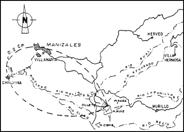 |
Figure 32. Preliminary isopach map of the 1 September 1989 eruption. Courtesy of the Observatorio Vulcanológico de Colombia. |
The Nimbus-7 satellite's TOMS showed little or no enhancement in SO2 values as it gathered data over the Ruiz area at about local noon on 1 and 2 September. Heavy weather clouds obscured the area, and no plume was detected on weather satellite images.
The Observatorio Vulcanológico de Colombia and the Comité Regional de Emergencia declared a red alert at 0450 and triggered sirens along the principal rivers. Evacuation began from 16 communities (total population <5,000) within 10 km of the crater. As eruptive and seismic activity had declined, the alert status was downgraded to orange at about 1500 and residents were allowed to return to their homes.
The next morning, the vigorous 200-300-m gas plume that was emerging from the summit did not appear to contain any ash. Rates of SO2 emission measured by COSPEC were roughly 2,500-3,500 t/d the day after the eruption, and had risen to 6,000 t/d on 3 September; similar increases have been observed after previous eruptive episodes. The pH of hot springs 7 km NNE and 11 km NW of the crater (at Aguas Calientes and Hotel Termales) had dropped from previous values of 1.2-1.5 to 0.84 and 0.94, but temperatures remained unchanged. Changes in temperature, pH, and sulfur/chlorine ratios had been detected at the same hot springs in late 1986. A M 3.3 earthquake centered under the crater occurred on 5 September at 1845. This event was felt and subterranean noises were heard in the 10-km evacuation area. As of 15 September, no additional strong eruptive activity had occurred. Strong seismicity was continuous, dominated by high-frequency earthquakes centered 6 km W of Arenas Crater at 4-6 km depth. Some of the events have been felt near the volcano.
Geological Summary. Nevado del Ruiz is a broad, glacier-covered volcano in central Colombia that covers more than 200 km2. Three major edifices, composed of andesitic and dacitic lavas and andesitic pyroclastics, have been constructed since the beginning of the Pleistocene. The modern cone consists of a broad cluster of lava domes built within the caldera of an older edifice. The 1-km-wide, 240-m-deep Arenas crater occupies the summit. The prominent La Olleta pyroclastic cone located on the SW flank may also have been active in historical time. Steep headwalls of massive landslides cut the flanks. Melting of its summit icecap during historical eruptions, which date back to the 16th century, has resulted in devastating lahars, including one in 1985 that was South America's deadliest eruption.
Information Contacts: C. Carvajal, F. Muñoz, and A. Nieto, INGEOMINAS, Manizales; S. Williams, Louisiana State Univ; N. Banks, CVO; S. Doiron, GSFC; J. Smith, AID/OFDA, Bogotá.