Report on Kelimutu (Indonesia) — November 1989
Scientific Event Alert Network Bulletin, vol. 14, no. 11 (November 1989)
Managing Editor: Lindsay McClelland.
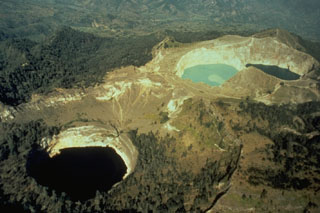
Kelimutu (Indonesia) Degassing from one of three crater lakes and flank fumaroles
Please cite this report as:
Global Volcanism Program, 1989. Report on Kelimutu (Indonesia) (McClelland, L., ed.). Scientific Event Alert Network Bulletin, 14:11. Smithsonian Institution. https://doi.org/10.5479/si.GVP.SEAN198911-264140
Kelimutu
Indonesia
8.77°S, 121.82°E; summit elev. 1639 m
All times are local (unless otherwise noted)
In November, moderate degassing with a weak sulfur odor occurred from the the E crater's Tiwu Ata Polo, reddish in 1986 and dark green in 1989. No degassing was evident from the light green Tiwu Nua Muri Kooh Tai in the central crater. A small amount of sulfur was deposited around the lakeshore. In the W crater, Tiwu Ata Mbupu, dark brown in May, was greenish in November. No degassing or other activity was evident. Fumaroles on the upper flanks had temperatures of [96-97°C] in 21°C air. An earthquake was felt at MM II on 28 June at 2255. November seismicity included [three] A-type and [two] B-type events, plus [23] local and [37] distant tectonic earthquakes.
Geological Summary. Kelimutu is a small, but well-known, Indonesian compound volcano in central Flores Island with three summit crater lakes of varying colors. The western lake, Tiwi Ata Mbupu (Lake of Old People) is commonly blue. Tiwu Nua Muri Kooh Tai (Lake of Young Men and Maidens) and Tiwu Ata Polo (Bewitched, or Enchanted Lake), which share a common crater wall, are commonly colored green and red, respectively, although lake colors periodically vary. Active upwelling, probably fed by subaqueous fumaroles, occurs at the two eastern lakes. The scenic lakes are a popular tourist destination and have been the source of minor phreatic eruptions in historical time. The summit is elongated 2 km in a WNW-ESE direction; the older cones of Kelido (3 km N) and Kelibara (2 km S).
Information Contacts: VSI.