Report on St. Helens (United States) — November 1989

Scientific Event Alert Network Bulletin, vol. 14, no. 11 (November 1989)
Managing Editor: Lindsay McClelland.
St. Helens (United States) Minor ash emission and shallow seismicity
Please cite this report as:
Global Volcanism Program, 1989. Report on St. Helens (United States) (McClelland, L., ed.). Scientific Event Alert Network Bulletin, 14:11. Smithsonian Institution. https://doi.org/10.5479/si.GVP.SEAN198911-321050
St. Helens
United States
46.2°N, 122.18°W; summit elev. 2549 m
All times are local (unless otherwise noted)
A small ash emission episode on 6 Decembrt was associated with ~5 hours of shallow seismicity. The activity occurred during poor weather, preventing direct observation of the volcano. The seismicity, dominated by a tremor-like signal that was punctuated by individual shallow (less than or equal to 2 km deep) earthquakes centered under the summit lava dome, was recorded between 1609 and 2122. Continuously recording tiltmeters in the crater showed small offsets during the seismicity, and a strainmeter crossing a crack on the W side of the dome measured 2 cm of contemporaneous extension.
Geologists working in the crater a few days later found a thin layer of new ash. Maximum thickness was 8 mm on the W side of the dome, rapidly thinning to a dusting on snow E and N of the dome. All of the ash appeared to be lithic material, without fresh glass shards or vesiculated magma. No new vent was evident, and geologists assumed that the ash had emerged from existing cracks near the dome's summit. Deformation measurements revealed changes of as much as 12 cm on the W side of the dome, declining to barely above noise level on its S side, since the previous fieldwork on 22 November. Deformation data had not previously shown any changes.
The last eruptive activity at Mt. St. Helens was a dome building episode in October 1986 (SEAN 11:09 and 11:10). At least nine periods of increased seismicity have been documented since late 1987 (figure 42), most recently for 10 days beginning 19 October 1989 (SEAN 14:10). Three brief swarms in late August, more energetic than the December activity but without the extended tremor-like signal, resembled seismicity associated with previous ash emission episodes. However, no eruptive activity was documented at that time (SEAN 14:08).
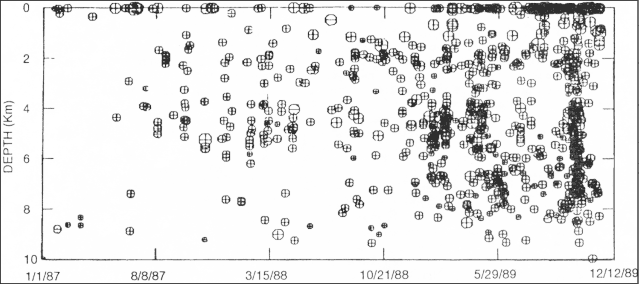 |
Figure 42. Space-time plot showing focal depths of earthquakes at Mt. St. Helens, 1 January 1987-12 December 1989. Courtesy of C. Jonientz-Trisler. |
Geological Summary. Prior to 1980, Mount St. Helens was a conical volcano sometimes known as the Fujisan of America. During the 1980 eruption the upper 400 m of the summit was removed by slope failure, leaving a 2 x 3.5 km breached crater now partially filled by a lava dome. There have been nine major eruptive periods beginning about 40-50,000 years ago, and it has been the most active volcano in the Cascade Range during the Holocene. Prior to 2,200 years ago, tephra, lava domes, and pyroclastic flows were erupted, forming the older edifice, but few lava flows extended beyond the base of the volcano. The modern edifice consists of basaltic as well as andesitic and dacitic products from summit and flank vents. Eruptions in the 19th century originated from the Goat Rocks area on the N flank, and were witnessed by early settlers.
Information Contacts: D. Swanson, CVO; C. Jonientz-Trisler and S. Malone, University of Washington.