Report on Redoubt (United States) — 8 April-14 April 2009
Smithsonian Institution / US Geological Survey
Weekly Volcanic Activity Report, 8 April-14 April 2009
Managing Editor: Sally Sennert.
Please cite this report as:
Global Volcanism Program, 2009. Report on Redoubt (United States) (Sennert, S, ed.). Weekly Volcanic Activity Report, 8 April-14 April 2009. Smithsonian Institution and US Geological Survey.
Redoubt
United States
60.485°N, 152.742°W; summit elev. 3108 m
All times are local (unless otherwise noted)
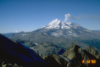
Based on seismic data and satellite imagery, AVO reported that Redoubt's lava dome continued to grow during 8-14 April. On 8 April, a small steam plume possibly containing ash was seen on satellite imagery and on the web camera, and drifted NE at low altitudes. A continuous sulfur dioxide plume seen on satellite imagery drifted 965 km. On 9 April, RADAR data showed no significant ash emissions. An M 3.3 earthquake was located about 4 km ENE of the summit. Observations showed that the lava dome grew in the same location as the previous lava dome, was circular in shape, and 400 m in diameter. A report on 10 April indicated that seismicity had remained steady since the last explosion on 4 April; small repetitive volcanic earthquakes were detected. Gas, steam, and ash emitted from the vent formed a plume that rose to an altitude less than 4.6 km (15,000 ft) a.s.l. On 11 April, A vigorous steam plume that may have contained small amounts of ash was visible on the web camera. Satellite imagery showed a plume that drifted NW at altitudes below 6.1 km (20,000 ft) a.s.l. Observations on 13 and 14 April were obscured by clouds. The Volcanic Alert Level remained at Watch and the Aviation Color Code remained at Orange.
Geological Summary. Redoubt is a glacier-covered stratovolcano with a breached summit crater in Lake Clark National Park about 170 km SW of Anchorage. Next to Mount Spurr, Redoubt has been the most active Holocene volcano in the upper Cook Inlet. The volcano was constructed beginning about 890,000 years ago over Mesozoic granitic rocks of the Alaska-Aleutian Range batholith. Collapse of the summit 13,000-10,500 years ago produced a major debris avalanche that reached Cook Inlet. Holocene activity has included the emplacement of a large debris avalanche and clay-rich lahars that dammed Lake Crescent on the south side and reached Cook Inlet about 3,500 years ago. Eruptions during the past few centuries have affected only the Drift River drainage on the north. Historical eruptions have originated from a vent at the north end of the 1.8-km-wide breached summit crater. The 1989-90 eruption had severe economic impact on the Cook Inlet region and affected air traffic far beyond the volcano.
Source: US Geological Survey Alaska Volcano Observatory (AVO)