Report on Slamet (Indonesia) — 27 May-2 June 2009
Smithsonian Institution / US Geological Survey
Weekly Volcanic Activity Report, 27 May-2 June 2009
Managing Editor: Sally Sennert.
Please cite this report as:
Global Volcanism Program, 2009. Report on Slamet (Indonesia) (Sennert, S, ed.). Weekly Volcanic Activity Report, 27 May-2 June 2009. Smithsonian Institution and US Geological Survey.
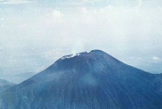
Slamet
Indonesia
7.242°S, 109.208°E; summit elev. 3428 m
All times are local (unless otherwise noted)
Based on ground information from CVGHM, the Darwin VAAC reported that on 27 May an ash plume from Slamet rose to an altitude of 4.3 km (14,000 ft) a.s.l. Analysis of satellite imagery indicated that a possible plume rose to an altitude of 6.1 km (20,000 ft) a.s.l., but ash was not conclusively detected.
Geological Summary. Slamet is one of Java's most active volcanoes. It has a cluster of about three dozen cinder cones on its lower SE-NE flanks and a single cinder cone on the W flank. It is composed of two overlapping edifices, an older basaltic andesite to andesitic volcano on the west and a younger basaltic to basaltic andesite one on the east. Gunung Malang II cinder cone on the upper E flank on the younger edifice fed a lava flow that extends 6 km E. Four craters occur at the summit of Gunung Slamet, with activity migrating to the SW over time. Eruptions recorded since the 18th century have originated from a 150-m-deep, 450-m-wide, steep-walled crater at the western part of the summit and have consisted of explosive eruptions generally lasting a few days to a few weeks.