Report on Eyjafjallajokull (Iceland) — 28 April-4 May 2010
Smithsonian Institution / US Geological Survey
Weekly Volcanic Activity Report, 28 April-4 May 2010
Managing Editor: Sally Sennert.
Please cite this report as:
Global Volcanism Program, 2010. Report on Eyjafjallajokull (Iceland) (Sennert, S, ed.). Weekly Volcanic Activity Report, 28 April-4 May 2010. Smithsonian Institution and US Geological Survey.
Eyjafjallajokull
Iceland
63.633°N, 19.633°W; summit elev. 1651 m
All times are local (unless otherwise noted)
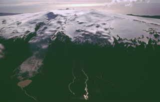
The Institute of Earth Sciences at the Nordic Volcanological Center (NVC) reported that during 28 April-4 May the eruption from Eyjafjallajökull continued to emit lava and produce steam and ash plumes. Booming sounds in the vicinity of the volcano were often heard. Scientists continued to measure meltwater discharge that flowed down the Gígjökull glacier into the Gígjökull lake basin, then into the Markarfljót River. On 30 April steaming blocks were deposited in the basin, and on 2 May, steam rising from the delta in the lake basin suggested near-boiling water temperatures.
On 28 April the eruption plume was not detected over 4 km altitude (13,100 ft) a.s.l., the level of meteorological clouds. Steam plumes rose above the lava that advanced N down the Gígjöjkull Glacier. Ash plumes rose above the crater; ashfall was seen on the W flanks and in an area about 32 km W. The next day the eruption plume was not visible, but likely did not exceed an altitude of 3.6 km (11,800 ft) a.s.l. Ashfall was reported in areas 1.5 km SW and 12 km SSW.
Steam plumes on 30 April rose to altitude of 4.5-5.1 km (14,800-16,700 ft) a.s.l. Ash plumes rose to lower altitudes, drifted S, and deposited ash in areas 10 km away. Ash plumes rose slightly higher the next day, to an altitude of 5.4 km (17,700 ft) a.s.l. Ashfall was noted in areas 22 km SE. An active lava flow to the N continued to generate steam plumes from interaction with ice.
A report on 2 May stated that during the previous 2-3 days ash plumes had become darker and wider than in the preceding week, explosivity had increased, and tephra fall-out had increased. The location of the steam plume N of the crater indicated that the lava flow had advanced more than 3 km from the crater. Steam and ash plumes continued to rise from the crater. Ashfall was reported in an area 40 km SE. The scoria cone at the crater continued to build. Conditions on 3 May were similar. The largest eruption plume rose to an altitude of 5.5 km (18,000 ft) a.s.l. Ashfall was noted 65-70 km ESE, and ash plumes were seen over the village of Vík, 40 km SE. The eruption plume was seen in satellite imagery as far as 200 km from Eyjafjallajökull on both days.
On 4 May ash plumes rose above the crater and steam plumes rose from the N flank. Lava had traveled 4 km N from the crater, and lava was ejected a few hundred meters from the crater. Ashfall was reported in areas 65-80 km ESE, cutting visibility to less than a few kilometers. An eruption plume was seen in satellite imagery as far as 400 km ESE to SE. According to news articles, airports throughout Ireland were temporarily shut down on 4 May due to ash-plume hazards.
Geological Summary. Eyjafjallajökull (also known as Eyjafjöll) is located west of Katla volcano. It consists of an elongated ice-covered stratovolcano with a 2.5-km-wide summit caldera. Fissure-fed lava flows occur on both the E and W flanks, but are more prominent on the western side. Although the volcano has erupted during historical time, it has been less active than other volcanoes of Iceland's eastern volcanic zone, and relatively few Holocene lava flows are known. An intrusion beneath the S flank from July-December 1999 was accompanied by increased seismic activity. The last historical activity prior to an eruption in 2010 produced intermediate-to-silicic tephra from the central caldera during December 1821 to January 1823.
Sources: Associated Press, Institute of Earth Sciences