Report on Galunggung (Indonesia) — 23 May-29 May 2012
Smithsonian Institution / US Geological Survey
Weekly Volcanic Activity Report, 23 May-29 May 2012
Managing Editor: Sally Sennert.
Please cite this report as:
Global Volcanism Program, 2012. Report on Galunggung (Indonesia) (Sennert, S, ed.). Weekly Volcanic Activity Report, 23 May-29 May 2012. Smithsonian Institution and US Geological Survey.
Galunggung
Indonesia
7.25°S, 108.058°E; summit elev. 2168 m
All times are local (unless otherwise noted)
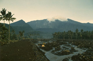
CVGHM reported that, since the Alert Level was raised on 12 February, seismic activity at Galunggung had drastically decreased through 27 May. During 27 April-27 May plants around the crater area looked green and lush, small fish were swimming in the water, and insects around the crater were active. Based on seismic data, crater lake water temperature and pH data, and visual observations, CVGHM lowered the Alert Level from 2 to 1 (on a scale of 1-4) on 28 May.
Geological Summary. The forested slopes of Galunggung in western Java SE of Bandung are cut by a 2-km-wide collapse scarp open towards the ESE. The "Ten Thousand Hills of Tasikmalaya" dotting the plain below the volcano are debris-avalanche hummocks from the collapse about 4,200 years ago. An eruption in 1822 produced pyroclastic flows and lahars that killed over 4,000 people. A series of major explosive eruptions starting in April 1982 destroyed a number of villages, killed as many as 30 people, and forced over 60,000 to evacuate. Pyroclastic flows and heavy widespread ash caused significant damage. A large passenger jet that encountered the ash plume on 24 June lost power to all four engines but managed to land safely in Jakarta. The 1982 activity destroyed a 1918 dome and formed the Warirang crater, almost as wide as the valley, about 2 km down from the summit.
Source: Pusat Vulkanologi dan Mitigasi Bencana Geologi (PVMBG, also known as CVGHM)