Report on Katla (Iceland) — 28 September-4 October 2016
Smithsonian Institution / US Geological Survey
Weekly Volcanic Activity Report, 28 September-4 October 2016
Managing Editor: Sally Sennert.
Please cite this report as:
Global Volcanism Program, 2016. Report on Katla (Iceland) (Sennert, S, ed.). Weekly Volcanic Activity Report, 28 September-4 October 2016. Smithsonian Institution and US Geological Survey.
Katla
Iceland
63.633°N, 19.083°W; summit elev. 1490 m
All times are local (unless otherwise noted)
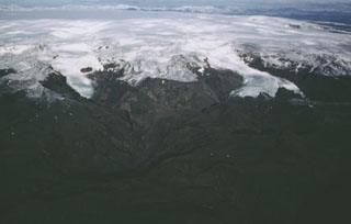
The Iceland Met Office (IMO) reported that an intense seismic swarm began at Katla on 29 September. The activity intensified again at 1202 on 30 September with tremor and several earthquakes M 3 or larger. The Aviation Color Code was raised to Yellow, the second highest level on a four-color scale. On 3 October IMO stated that the seismic swarm was the largest one in decades, though it appeared to be over. According to a news article from 3 October popular travel destinations near the glacier had been and remained closed to traffic.
Geological Summary. Katla volcano, located near the southern end of Iceland's eastern volcanic zone, is hidden beneath the Myrdalsjökull icecap. The subglacial basaltic-to-rhyolitic volcano is one of Iceland's most active and is a frequent producer of damaging jökulhlaups, or glacier-outburst floods. A large 10 x 14 km subglacial caldera with a long axis in a NW-SE direction is up to 750 m deep. Its high point reaches 1380 m, and three major outlet glaciers have breached its rim. Although most recorded eruptions have taken place from fissures inside the caldera, the Eldgjá fissure system, which extends about 60 km to the NE from the current ice margin towards Grímsvötn volcano, has been the source of major Holocene eruptions. An eruption from the Eldgjá fissure system about 934 CE produced a voluminous lava flow of about 18 km3, one of the world's largest known Holocene lava flows. Katla has been the source of frequent subglacial basaltic explosive eruptions that have been among the largest tephra-producers in Iceland during historical time and has also produced numerous dacitic explosive eruptions during the Holocene.
Sources: Icelandic Meteorological Office (IMO), Iceland Magazine