Report on Barren Island (India) — 15 February-21 February 2017
Smithsonian Institution / US Geological Survey
Weekly Volcanic Activity Report, 15 February-21 February 2017
Managing Editor: Sally Sennert.
Please cite this report as:
Global Volcanism Program, 2017. Report on Barren Island (India) (Sennert, S, ed.). Weekly Volcanic Activity Report, 15 February-21 February 2017. Smithsonian Institution and US Geological Survey.
Barren Island
India
12.278°N, 93.858°E; summit elev. 354 m
All times are local (unless otherwise noted)
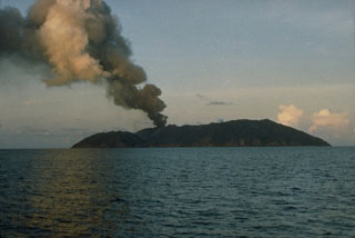
The National Institute of Oceanography (NIO), part of the Council of Scientific and Industrial Research (CSIR), reported that a new eruption at Barren Island began on 23 January. Scientists aboard a research vessel were collecting sea floor samples when they observed a sudden ash emission. The team moved closer, about 1.6 km from the volcano, and noted small eruptive episodes lasting 5-10 minutes. Ash emissions were visible in the daytime, and lava fountains feeding lava flows on the flanks were visible at night. The team revisited the volcano on 26 January and observed similar activity during the four hours they stayed. They sampled sediments and water in the vicinity of the eruption and recovered volcanic ejecta.
Geological Summary. Barren Island, a possession of India in the Andaman Sea about 135 km NE of Port Blair in the Andaman Islands, is the only historically active volcano along the N-S volcanic arc extending between Sumatra and Burma (Myanmar). It is the emergent summit of a volcano that rises from a depth of about 2250 m. The small, uninhabited 3-km-wide island contains a roughly 2-km-wide caldera with walls 250-350 m high. The caldera, which is open to the sea on the west, was created during a major explosive eruption in the late Pleistocene that produced pyroclastic-flow and -surge deposits. Historical eruptions have changed the morphology of the pyroclastic cone in the center of the caldera, and lava flows that fill much of the caldera floor have reached the sea along the western coast.

