Report on Ambrym (Vanuatu) — 12 December-18 December 2018
Smithsonian Institution / US Geological Survey
Weekly Volcanic Activity Report, 12 December-18 December 2018
Managing Editor: Sally Sennert.
Please cite this report as:
Global Volcanism Program, 2018. Report on Ambrym (Vanuatu) (Sennert, S, ed.). Weekly Volcanic Activity Report, 12 December-18 December 2018. Smithsonian Institution and US Geological Survey.
Ambrym
Vanuatu
16.25°S, 168.12°E; summit elev. 1334 m
All times are local (unless otherwise noted)
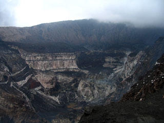
The Vanuatu Meteorology and Geo-hazards Department (VMGD) reported that a fissure eruption in the ESE part of the Ambrym summit caldera near the Lewlembwi crater (4 km SE of Marum) began at 0600 on 15 December, heralded by elevated seismicity detected by the seismic network and ash emissions visible in the webcam. A notice issued later that day by VMGD stated that lava flows and lava fountains were visible, and explosions were occurring. John Tasso, a local guide, visited the caldera a few hours after the new activity started and observed lava fountains from a fissure eruption; his video was posted to his website. The lava fountains were about 40 m high; lava flows spread to the E part of the caldera. Although partially obscured by a steam plume directly above the eruption site, infrared imagery from the Sentinel-2 satellite on 15 December showed lava filling much of the 500 x 900 m Lewlembwi crater and a lava flow almost as large a few hundred meters SW of that crater. VMGD raised the Alert Level to 3 and stated that the eruption was characterized as “small scale.” The eruption continued during 16-17 December, though reports on 17 December only described ongoing ash-and-gas emissions.
Geological Summary. Ambrym is a large basaltic volcano with a 12-km-wide caldera formed during a major Plinian eruption with dacitic pyroclastic flows about 1,900 years ago. A thick, almost exclusively pyroclastic sequence, initially dacitic then basaltic, overlies lava flows of a pre-caldera shield volcano. Post-caldera eruptions, primarily from Marum and Benbow cones, have partially filled the caldera floor and produced lava flows that ponded on the floor or overflowed through gaps in the caldera rim. Post-caldera eruptions have also formed a series of scoria cones and maars along a fissure system oriented ENE-WSW. Eruptions have been frequently reported since 1774, though mostly limited to extra-caldera eruptions that would have affected local populations. Since 1950 observations of eruptive activity from cones within the caldera or from flank vents have occurred almost yearly.
Sources: Vanuatu Meteorology and Geohazards Department (VMGD), John Tasso, Vanuatu Island Experience, Port Vatu, West Ambrym, Vanuatu, Sentinel Hub