Report on Tanaga (United States) — 14 April-20 April 2021
Smithsonian Institution / US Geological Survey
Weekly Volcanic Activity Report, 14 April-20 April 2021
Managing Editor: Sally Sennert.
Please cite this report as:
Global Volcanism Program, 2021. Report on Tanaga (United States) (Sennert, S, ed.). Weekly Volcanic Activity Report, 14 April-20 April 2021. Smithsonian Institution and US Geological Survey.
Tanaga
United States
51.885°N, 178.146°W; summit elev. 1806 m
All times are local (unless otherwise noted)
AVO reported that communication was reestablished with two seismic stations on Tanaga, making a total of four operational stations. On 19 April AVO changed both the Aviation Color Code and the Volcano Alert Level to Green and Normal, respectively, reflecting the resumption of seismically monitoring unrest.
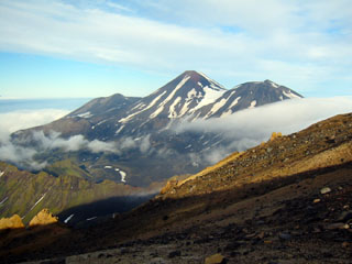
Geological Summary. Tanaga volcano, the second largest volcanic center of the central Aleutians, is the central and highest of three youthful stratovolcanoes oriented along a roughly E-W line at the NW tip of Tanaga Island. Ridges to the east and south represent the rim of an arcuate caldera formed by collapse of an edifice during the Pleistocene. Most Holocene eruptions originated from Tanaga volcano itself, which consists of two large cones, the western of which is the highest, constructed within a caldera whose 400-m-high rim is prominent to the SE. At the westernmost end of the complex is conical Sajaka, a double cone that may be the youngest of the three volcanoes. Sajaka One volcano collapsed during the late Holocene, producing a debris avalanche that swept into the sea, after which the Sajaka Two cone was constructed within the collapse scarp.
Source: US Geological Survey Alaska Volcano Observatory (AVO)