Report on Fukutoku-Oka-no-Ba (Japan) — 8 September-14 September 2021
Smithsonian Institution / US Geological Survey
Weekly Volcanic Activity Report, 8 September-14 September 2021
Managing Editor: Sally Sennert.
Please cite this report as:
Global Volcanism Program, 2021. Report on Fukutoku-Oka-no-Ba (Japan) (Sennert, S, ed.). Weekly Volcanic Activity Report, 8 September-14 September 2021. Smithsonian Institution and US Geological Survey.
Fukutoku-Oka-no-Ba
Japan
24.285°N, 141.481°E; summit elev. -29 m
All times are local (unless otherwise noted)
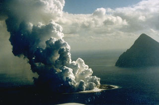
The Japan Coast Guard reported that during a 12 September overflight of Fukutoku-Oka-no-Ba, observers noted that the W island was unchanged while the E side had been completely eroded and submerged. Yellow-green to yellow-brown discolored water extended from the vent area to the SW, S, and SE, suggesting continuing eruptive activity. Another area of discolored water had an approximate diameter of 2 km and was about 2 km ENE of the volcano. The discolored water prompted JMA to issue a navigation warning to nearby vessels.
Geological Summary. Fukutoku-Oka-no-ba is a submarine volcano located 5 km NE of the island of Minami-Ioto. Water discoloration is frequently observed, and several ephemeral islands have formed in the 20th century. The first of these formed Shin-Ioto ("New Sulfur Island") in 1904, and the most recent island was formed in 1986. The volcano is part of an elongated edifice with two major topographic highs trending NNW-SSE, and is a trachyandesitic volcano geochemically similar to Ioto.
Source: Japan Coast Guard