Report on La Palma (Spain) — 15 September-21 September 2021
Smithsonian Institution / US Geological Survey
Weekly Volcanic Activity Report, 15 September-21 September 2021
Managing Editor: Sally Sennert.
Please cite this report as:
Global Volcanism Program, 2021. Report on La Palma (Spain) (Sennert, S, ed.). Weekly Volcanic Activity Report, 15 September-21 September 2021. Smithsonian Institution and US Geological Survey.
La Palma
Spain
28.57°N, 17.83°W; summit elev. 2426 m
All times are local (unless otherwise noted)
An eruption began at La Palma after about a week of intensifying seismicity that showed hypocenters becoming shallower and moving NW, and significant related inflation. During 17-18 September the PEVOLCA (Plan de Emergencias Volcánicas de Canarias) steering committee (comprised of representatives from multiple agencies, local authorities, and institutions) reviewed mitigation, evacuation, and emergency plans. Helicopter and drone overflights were conducted in areas thought to be at risk from an eruption. IGN reported that during 17-18 September seismicity decreased, though an M 2 felt by local residents was located at 100 m depth, and vertical deformation occurred near the earthquake epicenters.
IGN noted that seismicity intensified during the morning of 19 September, with earthquakes located at 0-6 km depth; a M 4.2 event was recorded at 1116 and vertical deformation increased. Authorities evacuated about 50 residents with reduced mobility and their companions from Las Manchas de Abajo, Jedey, San Nicolás and El Paraíso (El Paso and Los Llanos de Aridane), El Charco (Fuencaliente), La Bombilla (Los Llanos de Aridane and Tazacorte), and El Remo and Puerto Naos (Los Llanos de Aridane). Residents in an area prone to landslides were also evacuated. Other preparations continued at the hospital, in neighborhoods, and at evacuation centers.
At 1510 on 19 September an eruption began in the area of Cabeza de Vaca, in the municipality of El Paso. Observers near the eruption site observed a large explosion that ejected material and produced a gas-and-ash plume; volcanic tremor was recorded by the seismic network. Two 200-m-long fissures aligned N-S opened about 200 m apart. INVOLCAN scientists observed seven vents along the fissures during the initial stage of the eruption. Multiple tall lava fountains fed flows downslope to the W, igniting forest fires. Photos and video posted by IGN showed multiple pulsating fountains fanning out from parts of the fissure. Ash plumes rose about 1.5 km and gas plumes rose 3 km and drifted ESE. The PEVOLCA steering committee briefly raised the Alert Level to Orange, and then to Red (the highest level on a four-color scale) by 1700 for high-risk municipalities directly affected by the eruption. About 5,500 people evacuated with no injuries reported, and authorities recommended that residents stay at least 2 km from the vents. The La Palma airport briefly closed, livestock were evacuated, and education centers were closed along with sections of multiple highways. Later that day INVOLCAN scientists who measured an area of the flows determined an average flow rate of 700 m per hour and temperatures around 1,075 degrees Celsius. By the next day a main cone had formed.
The sulfur dioxide gas emission rate was 6,000-11,500 tons per day during 19-20 September. Satellite data showed a plume of sulfur dioxide drifting 475 km SE and reaching the coastline of Africa by 20 September. A map produced on 20 September by IGN in partnership with Copernicus Emergency Management Service (EMS) showed that the main part of the lava flow had traveled more than 3 km W and another branch extended about 1.5 km WSW. The flows had covered about 1 square kilometer and destroyed an estimated 166 buildings. A news article noted that activity was concentrated at four main vents, the last (and ninth) of which opened at 1956 on 20 September about 900 m from the main vents. Strong lava fountaining continued during 20-21 September and ash fell in the vicinity of the vents. Ash plumes rose 2.4-4.6 km (8,000-15,000 ft) a.s.l. and drifted as far as 55 km SW and S according to the Toulouse VAAC. Sulfur dioxide gas plumes drifted W and E at an altitude of 3 km (10,000 ft) a.s.l. By 0814 on 21 September an updated Copernicus EMS map showed that 350 homes had been covered by lava and the flow field had expanded to 1.54 square kilometers. According to a news report lava up to 12 m thick was advancing at a rate of 200 m per hour. A few hundred more residents evacuated as lava advanced towards Tacande; bringing the number of evacuees to about 5,700. The S lava branch was advancing slowly, at a rate of 2 m per hour. Later that day INVOLCAN stated that increased volcanic tremor amplitude reflected greater intensity of Strombolian explosions at the vents.
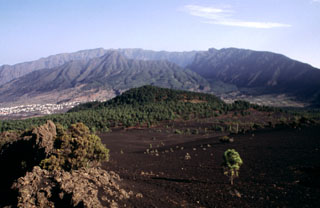
Geological Summary. The 47-km-long wedge-shaped island of La Palma, the NW-most of the Canary Islands, is composed of two large volcanic centers. The older northern one is cut by the steep-walled Caldera Taburiente, one of several massive collapse scarps produced by edifice failure to the SW. On the south, the younger Cumbre Vieja volcano is one of the most active in the Canaries. The elongated volcano dates back to about 125,000 years ago and is oriented N-S. Eruptions during the past 7,000 years have formed abundant cinder cones and craters along the axis, producing fissure-fed lava flows that descend steeply to the sea. Eruptions recorded since the 15th century have produced mild explosive activity and lava flows that damaged populated areas. The southern tip of the island is mantled by a broad lava field emplaced during the 1677-1678 eruption. Lava flows also reached the sea in 1585, 1646, 1712, 1949, 1971, and 2021.
Sources: Instituto Geográfico Nacional (IGN), Instituto Volcanológico de Canarias (INVOLCAN), Toulouse Volcanic Ash Advisory Centre (VAAC), Gobierno de Canaries, Gobierno de Canarias, Gobierno de Canarias, Advanced geospatial Data Management Platform (ADAM), Cabildo de La Palma, Cartografía Digital, 1-1-2 Canarias, Aviation24.be, El Periódico, rtvc Ente Público Radio Televisión Canaria, NOTICIAS 8 ISLAS