Report on Vulcano (Italy) — 29 September-5 October 2021
Smithsonian Institution / US Geological Survey
Weekly Volcanic Activity Report, 29 September-5 October 2021
Managing Editor: Sally Sennert.
Please cite this report as:
Global Volcanism Program, 2021. Report on Vulcano (Italy) (Sennert, S, ed.). Weekly Volcanic Activity Report, 29 September-5 October 2021. Smithsonian Institution and US Geological Survey.
Vulcano
Italy
38.404°N, 14.962°E; summit elev. 500 m
All times are local (unless otherwise noted)
INGV reported that hydrothermal activity at Vulcano increased in July, and notably more in September. Specifically, temperatures of the fumaroles on the crater rim and on the inner flank had increased along with the amounts of carbon dioxide and sulfur dioxide in the emissions. The highest temperature of 340 degrees Celsius was along the rim. The temperature and salinity of groundwater measured near the base of La Fossa cone were both elevated, and outgassing from ground sites was noted. On 13 September the seismic network detected a significant increase in microseismcity linked to hydrothermal processes. Additionally, very-long-period events were also recorded for the first time in 15 years when instrumentation able to detect the signals was installed. Deformation on the N side of the cone was first identified in mid-August and totaled 1 cm of uplift by mid-September. The report stated that new seismic stations and instruments to measure carbon dioxide emissions had been added to the monitoring network, and a thermal camera pointing at the fumarolic field was planned. The Dipartimento della Protezione Civile raised the Alert Level to Yellow (the second lowest level on a four-color scale) on 1 October.
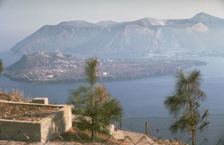
Geological Summary. The word volcano is derived from Vulcano stratovolcano in Italy's Aeolian Islands. Vulcano was constructed during six stages over the past 136,000 years. Two overlapping calderas, the 2.5-km-wide Caldera del Piano on the SE and the 4-km-wide Caldera della Fossa on the NW, were formed at about 100,000 and 24,000-15,000 years ago, respectively, and volcanism has migrated north over time. La Fossa cone, active throughout the Holocene and the location of most historical eruptions, occupies the 3-km-wide Caldera della Fossa at the NW end of the elongated 3 x 7 km island. The Vulcanello lava platform is a low, roughly circular peninsula on the northern tip of Vulcano that was formed as an island beginning more than 2,000 years ago and was connected to the main island in about 1550 CE. Vulcanello is capped by three pyroclastic cones and was active intermittently until the 16th century. Explosive activity took place at the Fossa cone from 1898 to 1900.
Sources: Sezione di Catania - Osservatorio Etneo (INGV), Dipartimento della Protezione Civile