Report on Home Reef (Tonga) — 8 November-14 November 2006
Smithsonian Institution / US Geological Survey
Weekly Volcanic Activity Report, 8 November-14 November 2006
Managing Editor: Sally Sennert.
Please cite this report as:
Global Volcanism Program, 2006. Report on Home Reef (Tonga) (Sennert, S, ed.). Weekly Volcanic Activity Report, 8 November-14 November 2006. Smithsonian Institution and US Geological Survey.
Home Reef
Tonga
18.992°S, 174.775°W; summit elev. -10 m
All times are local (unless otherwise noted)
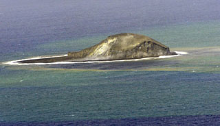
Pumice rafts originally reported to have been from Metis Shoal are now confirmed to have originated from an island-building eruption of the submarine Home Reef volcano. On 12 August, possibly four days after the beginning of the eruption, a sailor spotted the new island after encountering pumice rafts the previous day. The encounter was written in an on-line journal that described the island as four-peaked. A central crater produced steam plumes and occasional bursts of tephra.
Data from the Ozone Monitoring Instrument (OMI) on NASA's Aura satellite showed that sulfur dioxide emissions from the Home Reef area began on 8 August, peaked during 8-9 August, and ceased on 15 August. Based on ASTER satellite imagery from 4 October, the island was an estimated 1 km long with an area of 0.23 square km. The temperature of a small lake on the island was 64.7°C. The island was 0.15 square km, based on ASTER imagery from 12 October.
Geological Summary. Home Reef, a submarine volcano midway between Metis Shoal and Late Island in the central Tonga islands, was first reported active in the mid-19th century, when an ephemeral island formed. An eruption in 1984 produced a 12-km-high eruption plume, large amounts of floating pumice, and an ephemeral 500 x 1,500 m island, with cliffs 30-50 m high that enclosed a water-filled crater. In 2006 an island-forming eruption produced widespread dacitic pumice rafts that drifted as far as Australia. Another island was built during a September-October 2022 eruption.
Sources: Simon Carn, Fredrik Fransson, Alain Bernard