Report on Fourpeaked (United States) — 13 June-19 June 2007
Smithsonian Institution / US Geological Survey
Weekly Volcanic Activity Report, 13 June-19 June 2007
Managing Editor: Sally Sennert.
Please cite this report as:
Global Volcanism Program, 2007. Report on Fourpeaked (United States) (Sennert, S, ed.). Weekly Volcanic Activity Report, 13 June-19 June 2007. Smithsonian Institution and US Geological Survey.
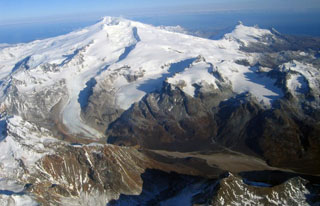
Fourpeaked
United States
58.77°N, 153.672°W; summit elev. 2105 m
All times are local (unless otherwise noted)
AVO reported that on 6 June the Volcanic Activity Alert Level for Fourpeaked was lowered from Advisory to Normal and the Aviation Color Code was lowered from Yellow to Green based on declining rates of seismicity and gas emission.
Geological Summary. Poorly known Fourpeaked volcano in NE Katmai National Park consists of isolated outcrops surrounded by the Fourpeaked Glacier, which descends eastward almost to the Shelikof Strait. The orientation of andesitic lava flows and extensive hydrothermal alteration of rocks near the present summit suggest that it probably marks the vent area. Eruptive activity during the Holocene had not been confirmed prior to the first historical eruption in September 2006. A N-trending fissure extending 1 km from the summit produced minor ashfall.
Source: US Geological Survey Alaska Volcano Observatory (AVO)