Report on Ol Doinyo Lengai (Tanzania) — 25 July-31 July 2007
Smithsonian Institution / US Geological Survey
Weekly Volcanic Activity Report, 25 July-31 July 2007
Managing Editor: Sally Sennert.
Please cite this report as:
Global Volcanism Program, 2007. Report on Ol Doinyo Lengai (Tanzania) (Sennert, S, ed.). Weekly Volcanic Activity Report, 25 July-31 July 2007. Smithsonian Institution and US Geological Survey.
Ol Doinyo Lengai
Tanzania
2.764°S, 35.914°E; summit elev. 2962 m
All times are local (unless otherwise noted)
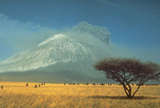
Ol Doinyo Lengai is frequently the scene of fluid but very small volume lava flows in its summit crater, including a few that passed over the crater rim and begun the long descent down the mountain. As noted here last week, news reports had indicated that products of the volcano's 19-July eruption had entered inhabited areas. Subsequent investigations have cast doubt on those earlier claims.
Discussions this week by volcanologist Gerald Ernst with contacts in the region revealed that neither aviators, guides, scientists, nor locals had seen dramatic eruptive events at the mountain. The summit crater was intact, but eruptions were confined to the summit area. What was interpreted from a distance as a modest landslide in the crater may have sent out a dust cloud. That cloud could have been confused with ash from a large flank eruption.
To help shed light on the situation, Greg Vaughan of the Jet Propulsion Labs had a preliminary look at some ASTER satellite data of the volcano and concluded that in mid-June through late July the summit crater was likely to have continued to emit lava. The 20 July thermal emissions appeared no larger than those on 18 June. Those from 15 April appeared weaker. The images supported summit lava eruptions but failed to document any lava that had spilled over the crater rim.
Geological Summary. The symmetrical Ol Doinyo Lengai is the only volcano known to have erupted carbonatite tephras and lavas in historical time. The prominent stratovolcano, known to the Maasai as "The Mountain of God," rises abruptly above the broad plain south of Lake Natron in the Gregory Rift Valley. The cone-building stage ended about 15,000 years ago and was followed by periodic ejection of natrocarbonatitic and nephelinite tephra during the Holocene. Historical eruptions have consisted of smaller tephra ejections and emission of numerous natrocarbonatitic lava flows on the floor of the summit crater and occasionally down the upper flanks. The depth and morphology of the northern crater have changed dramatically during the course of historical eruptions, ranging from steep crater walls about 200 m deep in the mid-20th century to shallow platforms mostly filling the crater. Long-term lava effusion in the summit crater beginning in 1983 had by the turn of the century mostly filled the northern crater; by late 1998 lava had begun overflowing the crater rim.
Sources: Gerald Ernst, Centre for Environmental & Geophysical Flows, Department of Earth Sciences, University of Bristol, Greg Vaughan, Jet Propulsion Laboratory

