
Smithsonian Institution / US Geological Survey
Weekly Volcanic Activity Report, 2 July-8 July 2008
Managing Editor: Sally Sennert
Please cite this report as:
Global Volcanism Program, 2008. Report on Kīlauea (United States) (Sennert, S, ed.). Weekly Volcanic Activity Report, 2 July-8 July 2008. Smithsonian Institution and US Geological Survey. https://volcano.si.edu/showreport.cfm?gvpvar=GVP.WVAR20080702-332010
Based on visual observations from HVO crews, video footage, pilot reports, and web camera views, HVO reported that during 2-8 July, lava flowed SE through a lava tube system from underneath Kīlauea's Thanksgiving Eve Breakout (TEB) and rootless shield complex. The TEB vent is located a little over 2 km NE of Puʻu ʻŌʻō crater. During 2-6 July, lava flows reached the Waikupanaha ocean entry and created a steam plume from contact with the water. Incandescence was also seen from surface lava flows at multiple breakout points along the lava tube system. On 7 July, seismic tremor levels near the TEB vent abruptly doubled, corresponding to a substantial new breakout in the rootless shield area. The steam plume at the Waikupanaha ocean entry was also absent that day and the next. An overflight revealed that a lava fountain from one of the breakouts on rootless shield 3 (about 1 km SE of the TEB vent) was 12-15 m high and fed several lava flows. The lava fountain and a lava pond were active during 7-8 July and incandescence at shield 6 (about 2 km SE of the TEB vent) was noted.
At Puʻu ʻŌʻō the sulfur dioxide emission rate fluctuated between 3,100 and 4,800 tonnes per day when measured during 4-6 July; the average background rate is about 2,000 tonnes per day. Incandescence from two distinct sources in the E and W ends of Puʻu ʻŌʻō crater was observed on the web camera during 4-6 July. Diffuse incandescence was noted during 7-8 July.
During the reporting period, Kīlauea earthquakes were located beneath the summit area, along S-flank faults, along the E and SW rift zones, beneath Halemaʻumaʻu crater, and beneath the area where the Koa'e fault system joins the upper E rift zone. Beneath Halemaʻumaʻu crater, another 20-100 small earthquakes per day also occurred but were too small to be located. The vent in the crater continued to produce a white plume with minor ash content that drifted mainly SW. Night-time incandescence was seen at the base of the plume. The sulfur dioxide emission rate was high, between 700 and 1,400 tonnes per day, during 2-7 July. The pre-2008 background rate was 150-200 tonnes per day.
Source: US Geological Survey Hawaiian Volcano Observatory (HVO)
Geological Summary. Kīlauea overlaps the E flank of the massive Mauna Loa shield volcano in the Island of Hawaiʻi. Eruptions are prominent in Polynesian legends; written documentation since 1820 records frequent summit and flank lava flow eruptions interspersed with periods of long-term lava lake activity at Halemaʻumaʻu crater in the summit caldera until 1924. The 3 x 5 km caldera was formed in several stages about 1,500 years ago and during the 18th century; eruptions have also originated from the lengthy East and Southwest rift zones, which extend to the ocean in both directions. About 90% of the surface of the basaltic shield volcano is formed of lava flows less than about 1,100 years old; 70% of the surface is younger than 600 years. The long-term eruption from the East Rift Zone between 1983 and 2018 produced lava flows covering more than 100 km2, destroyed hundreds of houses, and added new coastline.


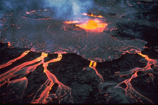 Kīlauea