Report on Nevado del Huila (Colombia) — 14 January-20 January 2009
Smithsonian Institution / US Geological Survey
Weekly Volcanic Activity Report, 14 January-20 January 2009
Managing Editor: Sally Sennert.
Please cite this report as:
Global Volcanism Program, 2009. Report on Nevado del Huila (Colombia) (Sennert, S, ed.). Weekly Volcanic Activity Report, 14 January-20 January 2009. Smithsonian Institution and US Geological Survey.
Nevado del Huila
Colombia
2.93°N, 76.03°W; summit elev. 5364 m
All times are local (unless otherwise noted)
INGEOMINAS reported that during 18-19 January continuous emissions from Nevado del Huila were observed on the web camera, and produced white plumes that rose to heights less than 1 km above the summit. The Alert Level remained at Orange (the second highest on a four-color scale).
According to news reports, authorities in Colombia announced on 19 January the decision to relocate the town of Páez (population of about 4,000), currently about 27 km SSE of Nevado del Huila, due to the town's proximity to the Páez river and the volcano. Several populations have been affected by lahars generated by glacier melting from the volcanic activity.
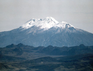
Geological Summary. Nevado del Huila, the highest peak in the Colombian Andes, is an elongated N-S-trending volcanic chain mantled by a glacier icecap. The andesitic-dacitic volcano was constructed within a 10-km-wide caldera. Volcanism at Nevado del Huila has produced six volcanic cones whose ages in general migrated from south to north. The high point of the complex is Pico Central. Two glacier-free lava domes lie at the southern end of the volcanic complex. The first historical activity was an explosive eruption in the mid-16th century. Long-term, persistent steam columns had risen from Pico Central prior to the next eruption in 2007, when explosive activity was accompanied by damaging mudflows.
Sources: Servicio Geológico Colombiano (SGC), Reuters

