Report on Nevado del Huila (Colombia) — 28 October-3 November 2009
Smithsonian Institution / US Geological Survey
Weekly Volcanic Activity Report, 28 October-3 November 2009
Managing Editor: Sally Sennert.
Please cite this report as:
Global Volcanism Program, 2009. Report on Nevado del Huila (Colombia) (Sennert, S, ed.). Weekly Volcanic Activity Report, 28 October-3 November 2009. Smithsonian Institution and US Geological Survey.
Nevado del Huila
Colombia
2.93°N, 76.03°W; summit elev. 5364 m
All times are local (unless otherwise noted)
INGEOMINAS reported that on 28 October a pulse of tremor from Nevado del Huila was followed by an ash plume that, according to the Washington VAAC, rose to an altitude of 8.3 km (27,200 ft) a.s.l. On 30 October and 2 November overflights revealed a high rate of lava dome growth compared to the previous observation on 23 October. An ash layer covered the W part of Pico Central. Continuous and intense degassing originated from areas that also exhibited thermal anomalies detected with a thermal imaging camera. Resulting gas plumes drifted NW. The volume estimate for the new lava dome was nearly 9 million cubic meters.
Based on analyses of satellite imagery, pilot observations, and web camera views, the Washington VAAC reported that on 31 October an ash plume drifted 65 km S. During 31 October-2 November, thermal anomalies were seen on satellite imagery. On 2 November, a small plume seen on the web camera drifted SE. Gas plumes, occasionally accompanied by ash plumes, drifted 35 km SE.
On 3 November, INGEOMINAS reported that a pulse of tremor was followed by an ash plume that, according to the VAAC, rose to an altitude of 11.3 km (37,100 ft) a.s.l. and drifted SW. Ashfall was reported in communities downwind. The VAAC also noted that another ash plume rose to an altitude below 6.7 km (22,000 ft) a.s.l. and drifted E. INGEOMINAS stated that residents of Mosoco (20 km SSW) saw collapses from the W side of the dome generate small pyroclastic flows and incandescence at night. The Alert Level remained at II (Orange; "probable eruption in term of days or weeks").
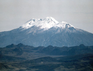
Geological Summary. Nevado del Huila, the highest peak in the Colombian Andes, is an elongated N-S-trending volcanic chain mantled by a glacier icecap. The andesitic-dacitic volcano was constructed within a 10-km-wide caldera. Volcanism at Nevado del Huila has produced six volcanic cones whose ages in general migrated from south to north. The high point of the complex is Pico Central. Two glacier-free lava domes lie at the southern end of the volcanic complex. The first historical activity was an explosive eruption in the mid-16th century. Long-term, persistent steam columns had risen from Pico Central prior to the next eruption in 2007, when explosive activity was accompanied by damaging mudflows.
Sources: Servicio Geológico Colombiano (SGC), Washington Volcanic Ash Advisory Center (VAAC)

