Report on Pacaya (Guatemala) — 3 February-9 February 2010
Smithsonian Institution / US Geological Survey
Weekly Volcanic Activity Report, 3 February-9 February 2010
Managing Editor: Sally Sennert.
Please cite this report as:
Global Volcanism Program, 2010. Report on Pacaya (Guatemala) (Sennert, S, ed.). Weekly Volcanic Activity Report, 3 February-9 February 2010. Smithsonian Institution and US Geological Survey.
Pacaya
Guatemala
14.382°N, 90.601°W; summit elev. 2569 m
All times are local (unless otherwise noted)
INSIVUMEH reported that activity from Pacaya consisting of effusion of lava flows, the source of which had migrated towards the S from the N flank since April 2006, ceased on 30 January 2010. On 5 February, Strombolian explosions from MacKenney cone ejected material 30 m into the air and lava from the crater moved down the flank. The activity was heard in the village of San Francisco de Sales, 5 km N. A new lava flow originating from a depression on the NE flank was seen on 6 February.
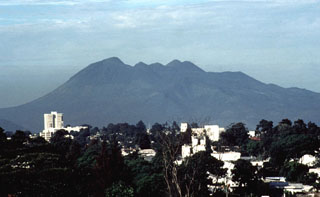
Geological Summary. Eruptions from Pacaya are frequently visible from Guatemala City, the nation's capital. This complex basaltic volcano was constructed just outside the southern topographic rim of the 14 x 16 km Pleistocene Amatitlán caldera. A cluster of dacitic lava domes occupies the southern caldera floor. The post-caldera Pacaya massif includes the older Pacaya Viejo and Cerro Grande stratovolcanoes and the currently active Mackenney stratovolcano. Collapse of Pacaya Viejo between 600 and 1,500 years ago produced a debris-avalanche deposit that extends 25 km onto the Pacific coastal plain and left an arcuate scarp inside which the modern Pacaya volcano (Mackenney cone) grew. The NW-flank Cerro Chino crater was last active in the 19th century. During the past several decades, activity has consisted of frequent Strombolian eruptions with intermittent lava flow extrusion that has partially filled in the caldera moat and covered the flanks of Mackenney cone, punctuated by occasional larger explosive eruptions that partially destroy the summit.
Source: Instituto Nacional de Sismologia, Vulcanologia, Meteorologia, e Hidrologia (INSIVUMEH)

