Report on South Sarigan Seamount (United States) — 9 June-15 June 2010
Smithsonian Institution / US Geological Survey
Weekly Volcanic Activity Report, 9 June-15 June 2010
Managing Editor: Sally Sennert.
Please cite this report as:
Global Volcanism Program, 2010. Report on South Sarigan Seamount (United States) (Sennert, S, ed.). Weekly Volcanic Activity Report, 9 June-15 June 2010. Smithsonian Institution and US Geological Survey.
South Sarigan Seamount
United States
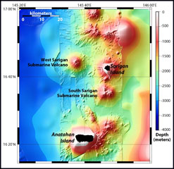
16.58°N, 145.78°E; summit elev. -184 m
All times are local (unless otherwise noted)
On 10 June the Volcano Alert Level and the Aviation Color Code for Sarigan was lowered to Unassigned because no further volcanic activity was noted since the submarine eruption from a vent S of the island on 29 May.
Geological Summary. South Sarigan seamount, rising to within about 184 m of the ocean surface 12 km S of Sarigan Island, was the site of a short explosive submarine eruption in May 2010 that produced a plume of ash and steam to 12 km altitude. Sidescan sonar imagery taken in 2003 shows an irregular summit with multiple peaks, including a possibly young cone at about 350 m depth, and flank morphology suggests it is a frequently active volcano.