Report on Melimoyu (Chile) — 9 June-15 June 2010
Smithsonian Institution / US Geological Survey
Weekly Volcanic Activity Report, 9 June-15 June 2010
Managing Editor: Sally Sennert.
Please cite this report as:
Global Volcanism Program, 2010. Report on Melimoyu (Chile) (Sennert, S, ed.). Weekly Volcanic Activity Report, 9 June-15 June 2010. Smithsonian Institution and US Geological Survey.
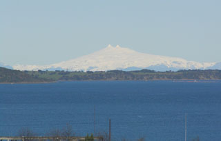
Melimoyu
Chile
44.08°S, 72.88°W; summit elev. 2400 m
All times are local (unless otherwise noted)
ODVAS-SERNAGEOMIN reported on 8 June that the Alert Level for Melimoyu was raised to Green Level 2 due to increased seismicity during May, specifically starting with nine long-period earthquakes on 27 May. The next day six long-period earthquakes preceded two separate seismic swarms. The first swarm was located 2-12 km beneath the summit. Earthquakes in the second swarm were located 7-14 km S of the summit at depths no greater than 15 km. All earthquakes were M 2.5 or less.
Geological Summary. Melimoyu is a stratovolcano with an 8-km-wide, largely buried caldera located ~40 km NW of the town of Puyuhuapi. The ice-filled caldera is drained by a glacier through a notch in the NE caldera rim. The basaltic andesite volcano is elongated 10 km in an E-W direction and has several cinder cones. A 1-km-wide crater is located at its summit, and two late-Holocene tephra layers have been documented.
Source: Servicio Nacional de Geología y Minería (SERNAGEOMIN)