Report on Ekarma (Russia) — 8 September-14 September 2010
Smithsonian Institution / US Geological Survey
Weekly Volcanic Activity Report, 8 September-14 September 2010
Managing Editor: Sally Sennert.
Please cite this report as:
Global Volcanism Program, 2010. Report on Ekarma (Russia) (Sennert, S, ed.). Weekly Volcanic Activity Report, 8 September-14 September 2010. Smithsonian Institution and US Geological Survey.
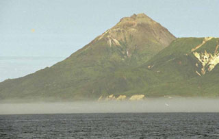
Ekarma
Russia
48.958°N, 153.93°E; summit elev. 1170 m
All times are local (unless otherwise noted)
On 13 September, SVERT reported that strong steam-and-gas activity from Ekarma continued. Ekarma does not have a seismic network; satellite image analysis and infrequent ground observations are the primary tool for monitoring many of the Kuril Islands volcanoes.
Geological Summary. The small 5 x 7.5 km island of Ekarma lies 8.5 km N of Shiashkotan Island along an E-W-trending volcanic chain extending westward from the central part of the main Kuril Island arc. It is composed of two overlapping basaltic andesite to andesitic volcanoes, the western of which has been historically active. Lava flows radiate 3 km in all directions from the summit of the younger cone to the sea, forming a lobate shoreline. A lava dome that was emplaced during the first historical eruption, in 1776-79, forms the peaked summit of the island.